1900s (20th Century) Maps of Uniontown, Alabama
Explore 6 historic maps of Uniontown from the 1900s (20th Century). These maps offer a rare glimpse into what life looked like during the 1900s — showing old roads, neighborhoods, homes, and landmarks that have changed or disappeared over time.
Whether you're researching your family's past, planning a metal detecting trip, or studying how Uniontown's landscape evolved across the 1900s, these high-resolution maps are a powerful tool for exploring the history of this region.
- Focus on a specific era: All maps on this page are from the 1900s, giving you a focused view of this time period.
- See what’s changed: Compare century-old streets, trails, and buildings to today's modern landscape using overlays and satellite layers.
- Research with precision: Use these maps for genealogy, historical research, land use analysis, or educational projects.
- View, download, or print: Maps are fully viewable online in high resolution, and can be downloaded or printed for your own records.
Start exploring Uniontown's history through authentic maps from the 1900s. This is your window into the past.
Uniontown, AL maps
(6)- 1953 Map of Montgomery, 1964 Print
 1953 Montgomery1964 Print · USGSCentral Alabama's river-and-rail corridor is mapped here in the mid-fifties, showing the vital connections between the capital and the Black Belt. Genealogists and historians can trace rail depots and crossroads from Marion Junction to Wetumpka, alongside landmarks like Craig AFB.4 unique versions available
 - 1956 Map of Montgomery
 1956 Montgomery1956 Print · USGSCentral Alabama in the mid-1950s shows a landscape defined by its great river systems and a booming military aviation presence. Genealogists and historians can trace the rail corridors of the Southern Railway and locate tactical bases like Maxwell AFB and Craig AFB.
 - 1957 Map of Montgomery
 1957 Montgomery1957 Print · USGSCentral Alabama in the mid-fifties is defined by the winding Alabama River and a strategic network of military bases and rail lines. Trace family roots in Montgomery and Selma, or locate landmarks like Craig AFB and the State Capitol before the interstate era.
 - 1968 Map of Uniontown West, 1971 Print
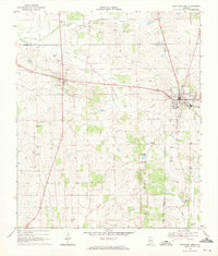 1968 Uniontown West1971 Print · USGSUniontown and Faunsdale sit at the center of this late-sixties survey of Alabama's Black Belt, following the route of the SOUTHERN railroad. Researchers can trace family history through local landmarks like St Michaels Cem, Siddonsville, and Hatch High Sch.3 unique versions available
 - 1968 Map of Uniontown East, 1971 Print
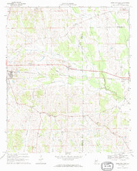 1968 Uniontown East1971 Print · USGSThe rural borderlands of Perry and Dallas Counties come into focus in the late 1960s as a landscape of rail-side settlements and aviation history. Researchers can trace the Southern railroad through Uniontown and Tayloe or locate community centers like White Hill Sch and Trinity Ch.
 - 1986 Map of Selma
 1986 Selma1986 Print · USGSCentral Alabama's river and rail networks are preserved here in the mid-eighties, showing the transition from river travel to modern infrastructure. Researchers can trace the layout of Selma, the historic capital at Cahaba, and the Millers Ferry Lock and Dam.2 unique versions available
End of results
Showing maps 1-6 of 6
Top cities near Uniontown
- Marion historical maps
- Thomaston historical maps
- Newbern historical maps
- Faunsdale historical maps
- Dayton historical maps
Top neighborhoods of Uniontown
- Ellawhite historical maps
- Hillcrest historical maps
- The Village historical maps
- Rabbityard historical maps
Frequently asked questions
- What are the different types of historical maps available for Uniontown?
- What is the oldest map of Uniontown?
- Where can I purchase historical maps of Uniontown for my home or office?
- Where can I download high-res historical maps of Uniontown?
- Are there historical topographic maps available for Uniontown?
- Is there historical aerial imagery available for Uniontown?
- Where are historical maps of Uniontown sourced from?