1970s Maps of Pickensville, Alabama
Explore 2 historic maps of Pickensville from the 1970s. These maps offer a rare glimpse into what life looked like during the 1970s — showing old roads, neighborhoods, homes, and landmarks that have changed or disappeared over time.
Whether you're researching your family's past, planning a metal detecting trip, or studying how Pickensville's landscape evolved across the 1970s, these high-resolution maps are a powerful tool for exploring the history of this region.
- Focus on a specific era: All maps on this page are from the 1970s, giving you a focused view of this time period.
- See what’s changed: Compare century-old streets, trails, and buildings to today's modern landscape using overlays and satellite layers.
- Research with precision: Use these maps for genealogy, historical research, land use analysis, or educational projects.
- View, download, or print: Maps are fully viewable online in high resolution, and can be downloaded or printed for your own records.
Start exploring Pickensville's history through authentic maps from the 1970s. This is your window into the past.
Pickensville, AL maps
(2)- 1970 Map of Aliceville North, 1972 Print
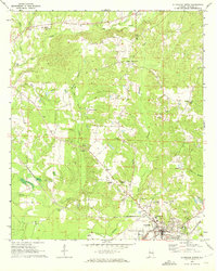 1970 Aliceville North1972 Print · USGSThe town of Aliceville and its rural surroundings in Pickens County are documented here during the early 1970s. Local researchers can locate family-named landmarks and institutions like Kirksey High Sch, Franconia Cem, and the Pilgrim Rest Ch.2 unique versions available
 - 1974 Map of Pickensville, 1975 Print
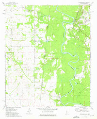 1974 Pickensville1975 Print · USGSSettlement patterns along the Tombigbee River and the Mississippi-Alabama border are captured here in the mid-seventies. Trace local genealogy at Beebe Chapel, Pickensville Sch, and several community burial grounds like Lower Cem.2 unique versions available
End of results
Showing maps 1-2 of 2
Top cities near Pickensville
- Aliceville historical maps
- Carrollton historical maps
- Macedonia historical maps
- Ethelsville historical maps
- McMullen historical maps
- Memphis historical maps
Frequently asked questions
- What are the different types of historical maps available for Pickensville?
- What is the oldest map of Pickensville?
- Where can I purchase historical maps of Pickensville for my home or office?
- Where can I download high-res historical maps of Pickensville?
- Are there historical topographic maps available for Pickensville?
- Is there historical aerial imagery available for Pickensville?
- Where are historical maps of Pickensville sourced from?