1970s Maps of Pike County, Alabama
Explore 2 historic maps of Pike County from the 1970s. These maps offer a rare glimpse into what life looked like during the 1970s — showing old roads, neighborhoods, homes, and landmarks that have changed or disappeared over time.
Whether you're researching your family's past, planning a metal detecting trip, or studying how Pike County's landscape evolved across the 1970s, these high-resolution maps are a powerful tool for exploring the history of this region.
- Focus on a specific era: All maps on this page are from the 1970s, giving you a focused view of this time period.
- See what’s changed: Compare century-old streets, trails, and buildings to today's modern landscape using overlays and satellite layers.
- Research with precision: Use these maps for genealogy, historical research, land use analysis, or educational projects.
- View, download, or print: Maps are fully viewable online in high resolution, and can be downloaded or printed for your own records.
Start exploring Pike County's history through authentic maps from the 1970s. This is your window into the past.
Pike County, AL maps
(2)- 1971 Map of China Grove, 1974 Print
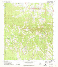 1971 China Grove1974 Print · USGSThe crossroads of Pike and Bullock counties are captured here in the early seventies, showing a landscape of small rural settlements. Genealogists can trace family footprints through numerous local landmarks like Bethesda Cem, Mt Olive Ch, and Shopton.2 unique versions available
 - 1979 Map of Elamville, 1984 Print
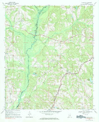 1979 Elamville1984 Print · USGSBarbour County and the Pike County line are shown in the late sixties as a network of small settlements and creek-side farms. Genealogists can trace family landmarks like Sutton Cem, Doster, and churches such as Sweet Oak Ch.
End of results
Showing maps 1-2 of 2
Top cities of Pike County
Frequently asked questions
- What are the different types of historical maps available for Pike County?
- What is the oldest map of Pike County?
- Where can I purchase historical maps of Pike County for my home or office?
- Where can I download high-res historical maps of Pike County?
- Are there historical topographic maps available for Pike County?
- Is there historical aerial imagery available for Pike County?
- Where are historical maps of Pike County sourced from?