1960s Maps of Pike County, Alabama
Explore 24 historic maps of Pike County from the 1960s. These maps offer a rare glimpse into what life looked like during the 1960s — showing old roads, neighborhoods, homes, and landmarks that have changed or disappeared over time.
Whether you're researching your family's past, planning a metal detecting trip, or studying how Pike County's landscape evolved across the 1960s, these high-resolution maps are a powerful tool for exploring the history of this region.
- Focus on a specific era: All maps on this page are from the 1960s, giving you a focused view of this time period.
- See what’s changed: Compare century-old streets, trails, and buildings to today's modern landscape using overlays and satellite layers.
- Research with precision: Use these maps for genealogy, historical research, land use analysis, or educational projects.
- View, download, or print: Maps are fully viewable online in high resolution, and can be downloaded or printed for your own records.
Start exploring Pike County's history through authentic maps from the 1960s. This is your window into the past.
Pike County, AL maps
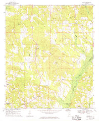
(24)- 1960 Map of Brundidge, 1963 Print
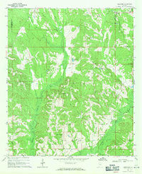
 1960 Brundidge1963 Print · USGSBrundidge and its surrounding rural landscapes are captured here during a period of steady growth and transition in the early sixties. Genealogists and local historians can trace family locations near landmarks like County High Sch, Hamilton Crossroads, and rural pulpits such as New Zion Ch.2 unique versions available
 - 1960 Map of Brundidge SE, 1963 Print
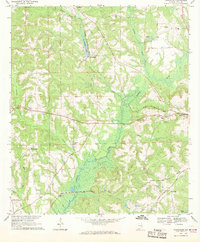
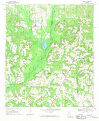
 1960 Brundidge SE1963 Print · USGSCoffee County during the early sixties is captured here as a landscape of river-bottom farms and small rail stops. Genealogists can trace the rural communities of Tennille, Roeton, and Java alongside historic landmarks like Prestwood Millpond and New Tabernacle Ch.2 unique versions available
 - 1960 Map of Victoria, 1963 Print
 1960 Victoria1963 Print · USGSDeep in the Alabama wiregrass region during the early sixties, this area shows a landscape defined by the winding Whitewater Creek and the Pea River. Researchers can trace rural life through landmarks like Lowry Mill, Clowers Crossroads, and Bethlehem Ch.2 unique versions available
 - 1960 Map of Brundidge NW, 1963 Print
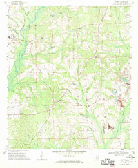
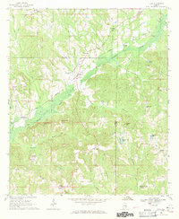
 1960 Brundidge NW1963 Print · USGSPike County settlements and early 1960s industry meet in this detailed survey of the Alabama countryside. Genealogists can trace family roots through numerous local landmarks like Spring Hill Sch, Antioch Ch, and the rural community of Tarentum.2 unique versions available
 - 1962 Map of Brundidge
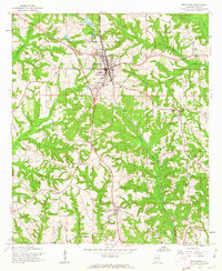
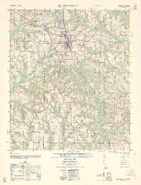 1962 Brundidge1962 Print · USGSThe Pike County town of Brundidge and its surrounding rural communities are captured here in the early 1960s. Genealogists and historians can trace local landmarks like Hamilton Crossroads, the Pike County High School, and numerous country churches such as Williams Chapel.
 - 1962 Map of Victoria
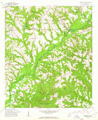
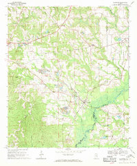
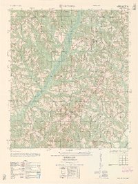 1962 Victoria1962 Print · USGSThe borderlands of Coffee and Pike County come alive in the early sixties, showing a landscape defined by small farms and country churches. Researchers can locate the Victoria School, the site of Lowry Mill, and local landmarks like Clowers Crossroads.
 - 1962 Map of Brundidge SE
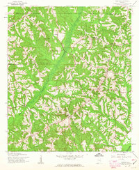
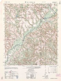 1962 Brundidge SE1962 Print · USGSCoffee and Dale counties in the early sixties reveal a landscape of river-bottom farms and emerging military installations. Genealogists can trace family roots through sites like Tennille, Roeton, and the Mt Olive Cemetery.
 - 1962 Map of Brundidge NW
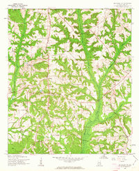
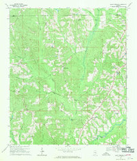
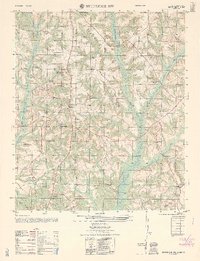 1962 Brundidge NW1962 Print · USGSLife in rural Pike County during the early sixties is detailed here through its network of country schools and churches. Genealogists can locate specific family landmarks like Springhill School, Tarentum, and the White Water Church (abandoned).
 - 1968 Map of Goshen, 1970 Print
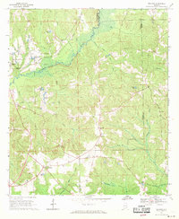
 1968 Goshen1970 Print · USGSGoshen and the Conecuh River valley are shown here in the late sixties as the local economy balanced traditional farming with emerging extractive industries. Genealogists can trace family names at Hillcrest Cem, Mt Hilliard Ch, and the crossroads at Little Oak.2 unique versions available
 - 1968 Map of Youngblood, 1970 Print
 1968 Youngblood1970 Print · USGSPike County in the late sixties reveals a landscape shaped by the Conecuh River and the intersecting routes of the Seaboard Coast Line. Researchers can locate several family-centric landmarks and rural congregations, from Hephzibah and Shellhorn to New Mt Zion Ch.2 unique versions available
 - 1968 Map of Bluff Springs, 1970 Print
 1968 Bluff Springs1970 Print · USGSSoutheast Alabama in the late sixties reveals a landscape of rural family churches and creek-side settlements along the Pike and Coffee County line. Genealogists and researchers can trace the vicinity of Bluff Springs, the historic Old Sharron Cem, and the crossings at Lewis Mill Bridge.2 unique versions available
 - 1968 Map of Glenwood, 1970 Print
 1968 Glenwood1970 Print · USGSCrenshaw and Pike counties appear here in the late sixties as a landscape of river-bottom farms and emerging strip mines. Genealogists can trace family names at Emmaus Cem and Shirleys Crossroads or follow the Georgia Central Railroad through Glenwood.2 unique versions available
 - 1968 Map of Perote, 1970 Print
 1968 Perote1970 Print · USGSSoutheastern Bullock County and its neighbors come alive in this late 1960s survey of Alabama's Black Belt region. Genealogists and local historians can trace family roots through rural landmarks like Blues Old Stand, Smuteye, and the Mt Hilliard Ch cemetery.
 - 1968 Map of Saco, 1971 Print
 1968 Saco1971 Print · USGSThe rural borderlands of Pike and Bullock Counties come into focus during the late sixties, where the Central of Georgia rail line skirts the Conecuh River. Researchers can trace local genealogy through numerous landmarks including Jones Chapel, Carrs Chapel, and the settlement of Saco.2 unique versions available
 - 1968 Map of Ansley, 1971 Print
 1968 Ansley1971 Print · USGSThe Pike and Montgomery county line in the late 1960s was a landscape of remote farmsteads and creek-side settlements. Genealogists can locate family landmarks like Shellhorn, the Seaboard Coast railroad corridor at Ansley, and several rural burial sites such as Pine Grove Cem.2 unique versions available
 - 1968 Map of Josie, 1971 Print
 1968 Josie1971 Print · USGSSoutheast Alabama’s rural borderlands are documented here in the late sixties, showing the small farming communities established along the Pea River valley. Genealogists and researchers can trace local families through many rural landmarks, including Hobdys Bridge, Ephesus Cem, and Loflin Ch.2 unique versions available
 - 1968 Map of Troy, 1971 Print
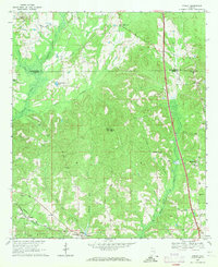
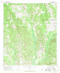
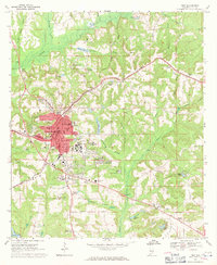 1968 Troy1971 Print · USGSPike County at the height of the 1960s shows a thriving regional center as Troy State Univ expands alongside established neighborhoods. Genealogists and historians can trace the foundations of the community through Oakwood Cem, the Seaboard Coast Line railroad, and McClure Town.2 unique versions available
 - 1968 Map of Bullock, 1971 Print
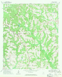
 1968 Bullock1971 Print · USGSCrenshaw County is documented here in the late sixties as the timber and rail economy shaped the rural landscape. Genealogists and local historians can locate many rural landmarks including Mt Zion Ch, Oak Grove Cem, and the Central of Georgia line.
 - 1968 Map of Petrey, 1971 Print
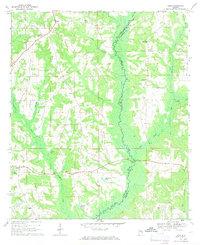
 1968 Petrey1971 Print · USGSSoutheast Alabama is captured here in the late sixties, showing the rural communities along the Crenshaw and Pike County line. Genealogists and historians can trace the Old Railroad Grade and locate ancestral sites like Petrey Cemetery and Camp Ground Church.
 - 1968 Map of Banks, 1971 Print
 1968 Banks1971 Print · USGSPike County's rural landscape is captured in the late sixties, as the Seaboard Coast Line railroad connected small hubs like Banks and Pronto. Genealogists can locate family landmarks such as Brooks Graves, Ramah Ch, and Bethel Sch.
 - 1968 Map of Needmore, 1971 Print
 1968 Needmore1971 Print · USGSSoutheast Alabama at the cusp of the 1970s reveals a quiet landscape of rural crossroads and river bottomlands. Researchers can locate family landmarks like Needmore, Tick Hill Cem, and Benevolent Grove Ch along the winding Conecuh River.
 - 1968 Map of Grady, 1971 Print
 1968 Grady1971 Print · USGSAgricultural life in the late sixties centers on the intersection of three counties and the SEABOARD COAST LINE railroad. Genealogists can trace family landmarks like Carter Cem, Shady Grove, and Rockelyn Ch along the Patsaliga Creek drainage.2 unique versions available
 - 1969 Map of Elamville, 1971 Print
 1969 Elamville1971 Print · USGSBarbour and Pike counties are captured in the late sixties as the Pea River wetlands and family farms shaped local life. Genealogists can trace rural roots through landmarks like St Pauls Cem Ch, the Central of Georgia rail line, and Sutton Cem.
 - 1969 Map of Ariton, 1971 Print
 1969 Ariton1971 Print · USGSSoutheast Alabama's Wiregrass region comes alive in the late sixties as a busy rail junction where two major lines meet. Genealogists can trace family names at the Universalist Cem, Sammon Cem, or the Pleasant Grove Ch (Cem).2 unique versions available
End of results
Showing maps 1-24 of 24
Top cities of Pike County
Frequently asked questions
- What are the different types of historical maps available for Pike County?
- What is the oldest map of Pike County?
- Where can I purchase historical maps of Pike County for my home or office?
- Where can I download high-res historical maps of Pike County?
- Are there historical topographic maps available for Pike County?
- Is there historical aerial imagery available for Pike County?
- Where are historical maps of Pike County sourced from?