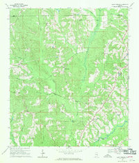
1968 Map of Bluff Springs
USGS Topo · Published 1970About this map
The boundary between Pike and Coffee counties defines this section of the Alabama landscape, where rural communities and small-scale infrastructure follow the winding course of Whitewater Creek and its many tributaries. Settlement patterns are focused around local landmarks such as Bluff Springs and Shady Grove, with the presence of Zion Chapel School and multiple country churches like Mt Hebron Ch and Zoar Ch indicating a network of closely-knit family farming communities.
Find a feature on this map
32 named features on this map. Tap any name to fly to it.
Don’t see what you’re looking for? This feature index may not catch every label — zoom into the map to look around manually.
Map Details
Editions of this 1968 Bluff Springs Map
2 editions found
Other maps of this area

1942 · Enterprise
USGS Topo · 1:125,000

1948 · Brundidge
USGS Topo · 1:62,500

1950 · Enterprise
USGS Topo · 1:62,500

1950 · Brundidge
USGS Topo · 1:62,500

1953 · Andalusia
USGS Topo · 1:250,000

1953 · Dothan
USGS Topo · 1:250,000

1954 · Dothan
USGS Topo · 1:250,000

1955 · Dothan
USGS Topo · 1:250,000

1957 · Andalusia
USGS Topo · 1:250,000

1960 · Victoria
USGS Topo · 1:24,000