1955 Map of Dothan
USGS Topo · Published 1955About this map
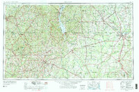
The Chattahoochee River forms a winding natural border between Alabama and Georgia on this mid-century survey, anchoring a region defined by agricultural hubs and burgeoning military aviation. Major population centers like Dothan and Albany serve as regional nodes for the Atlantic Coast Line RR and Central of Georgia RR, which moved the area's timber and crops. To the west, the Camp Rucker Military Reservation occupies a significant portion of the landscape, while Turner AFB near Albany highlights the era's strategic importance. Cultural and ancient history are present at Kolomoki Mounds State Park and the Andrew Jackson Monument. The map also captures the local industrial footprint through Bauxite mining operations and the rural social fabric preserved in small landmarks like Sardis Church and Ebenezer School.
Find a feature on this map
63 named features on this map. Tap any name to fly to it.
Don’t see what you’re looking for? This feature index may not catch every label — zoom into the map to look around manually.
Map Details
Editions of this 1955 Dothan Map
This is the sole edition of this map. No revisions or reprints were ever made.
Historical Maps of Albany Through Time
4 maps found