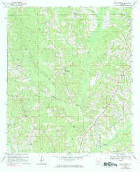
1968 Map of Bluff Springs
USGS Topo · Published 1984About this map
Bluff Springs sits at the heart of this late-1960s landscape, where the rural topography of Coffee County is defined by a dense network of creek branches and small community hubs. The area is marked by a scattering of local institutions that anchor the social history of the region, including Clay Hill Ch and the Zion Chapel Sch near Jack. The survey captures the transition of the land as it rises toward Coston Hill and drops into the bottomlands of Big Creek and Whitewater Creek.
Find a feature on this map
41 named features on this map. Tap any name to fly to it.
Don’t see what you’re looking for? This feature index may not catch every label — zoom into the map to look around manually.
Map Details
Editions of this 1968 Bluff Springs Map
2 editions found
Other maps of this area

1942 · Enterprise
USGS Topo · 1:125,000

1948 · Brundidge
USGS Topo · 1:62,500

1950 · Enterprise
USGS Topo · 1:62,500

1950 · Brundidge
USGS Topo · 1:62,500

1953 · Andalusia
USGS Topo · 1:250,000

1953 · Dothan
USGS Topo · 1:250,000

1954 · Dothan
USGS Topo · 1:250,000

1955 · Dothan
USGS Topo · 1:250,000

1957 · Andalusia
USGS Topo · 1:250,000

1960 · Victoria
USGS Topo · 1:24,000