1960s Maps of Windmill Hills, Brundidge
Explore 2 historic maps of Windmill Hills from the 1960s. These maps offer a rare glimpse into what life looked like during the 1960s — showing old roads, neighborhoods, homes, and landmarks that have changed or disappeared over time.
Whether you're researching your family's past, planning a metal detecting trip, or studying how Windmill Hills's landscape evolved across the 1960s, these high-resolution maps are a powerful tool for exploring the history of this region.
- Focus on a specific era: All maps on this page are from the 1960s, giving you a focused view of this time period.
- See what’s changed: Compare century-old streets, trails, and buildings to today's modern landscape using overlays and satellite layers.
- Research with precision: Use these maps for genealogy, historical research, land use analysis, or educational projects.
- View, download, or print: Maps are fully viewable online in high resolution, and can be downloaded or printed for your own records.
Start exploring Windmill Hills's history through authentic maps from the 1960s. This is your window into the past.
Windmill Hills, Brundidge maps
(2)- 1960 Map of Brundidge, 1963 Print
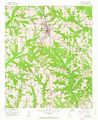 1960 Brundidge1963 Print · USGSBrundidge and its surrounding rural landscapes are captured here during a period of steady growth and transition in the early sixties. Genealogists and local historians can trace family locations near landmarks like County High Sch, Hamilton Crossroads, and rural pulpits such as New Zion Ch.2 unique versions available
 - 1962 Map of Brundidge
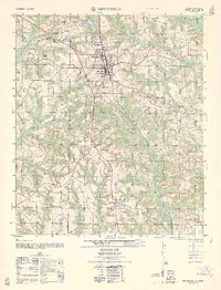 1962 Brundidge1962 Print · USGSThe Pike County town of Brundidge and its surrounding rural communities are captured here in the early 1960s. Genealogists and historians can trace local landmarks like Hamilton Crossroads, the Pike County High School, and numerous country churches such as Williams Chapel.
End of results
Showing maps 1-2 of 2
Top cities near Windmill Hills
- Troy historical maps
- Ozark historical maps
- Brundidge historical maps
- Clio historical maps
- Ariton historical maps
- Banks historical maps
Frequently asked questions
- What are the different types of historical maps available for Windmill Hills?
- What is the oldest map of Windmill Hills?
- Where can I purchase historical maps of Windmill Hills for my home or office?
- Where can I download high-res historical maps of Windmill Hills?
- Are there historical topographic maps available for Windmill Hills?
- Is there historical aerial imagery available for Windmill Hills?
- Where are historical maps of Windmill Hills sourced from?