1960s Maps of Mossy Grove Village, Alabama
Explore 2 historic maps of Mossy Grove Village from the 1960s. These maps offer a rare glimpse into what life looked like during the 1960s — showing old roads, neighborhoods, homes, and landmarks that have changed or disappeared over time.
Whether you're researching your family's past, planning a metal detecting trip, or studying how Mossy Grove Village's landscape evolved across the 1960s, these high-resolution maps are a powerful tool for exploring the history of this region.
- Focus on a specific era: All maps on this page are from the 1960s, giving you a focused view of this time period.
- See what’s changed: Compare century-old streets, trails, and buildings to today's modern landscape using overlays and satellite layers.
- Research with precision: Use these maps for genealogy, historical research, land use analysis, or educational projects.
- View, download, or print: Maps are fully viewable online in high resolution, and can be downloaded or printed for your own records.
Start exploring Mossy Grove Village's history through authentic maps from the 1960s. This is your window into the past.
Mossy Grove Village, AL maps
(2)- 1960 Map of Brundidge NW, 1963 Print
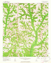 1960 Brundidge NW1963 Print · USGSPike County settlements and early 1960s industry meet in this detailed survey of the Alabama countryside. Genealogists can trace family roots through numerous local landmarks like Spring Hill Sch, Antioch Ch, and the rural community of Tarentum.2 unique versions available
 - 1962 Map of Brundidge NW
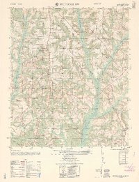 1962 Brundidge NW1962 Print · USGSLife in rural Pike County during the early sixties is detailed here through its network of country schools and churches. Genealogists can locate specific family landmarks like Springhill School, Tarentum, and the White Water Church (abandoned).
End of results
Showing maps 1-2 of 2
Top cities near Mossy Grove Village
- Troy historical maps
- Brundidge historical maps
- Ariton historical maps
- Goshen historical maps
- Banks historical maps
- Glenwood historical maps
Frequently asked questions
- What are the different types of historical maps available for Mossy Grove Village?
- What is the oldest map of Mossy Grove Village?
- Where can I purchase historical maps of Mossy Grove Village for my home or office?
- Where can I download high-res historical maps of Mossy Grove Village?
- Are there historical topographic maps available for Mossy Grove Village?
- Is there historical aerial imagery available for Mossy Grove Village?
- Where are historical maps of Mossy Grove Village sourced from?