Old Maps of Magnolia Park, Alabama
Explore 13 old maps of Magnolia Park, spanning from 1924 to today. These high-resolution historic maps reveal how streets, neighborhoods, landmarks, and natural features evolved over time — perfect for genealogy, metal detecting, research, and local history exploration.
What you can do with these maps:
- See how Magnolia Park changed over time: Compare historical maps to modern-day views to trace roads, homesites, rail lines & more.
- View detailed metadata: Each map includes creators, publishers, year, scale, and archive source.
- Overlay maps with satellite & LiDAR: Visualize the past alongside modern tools to explore terrain & human change.
- Trusted historical sources: Maps sourced from the USGS, Library of Congress, and other archives.
- Access maps your way: View online, download high-res files, or order prints for personal or research use.
Start exploring old maps of Magnolia Park to uncover forgotten places, hidden landmarks, and the deep history beneath your feet.
Magnolia Park, AL maps
(13)- 1924 Map of Tuscaloosa, 1957 Print
 1924 Tuscaloosa1957 Print · USGSTuscaloosa and the Black Warrior River valley are seen here in the mid-1920s, showing a landscape defined by river bends and rail lines. Researchers can trace the early footprint of the University of Alabama or locate rural sites like Cribbs Mill and Little Satan Church.
 - 1926 Map of Tuscaloosa
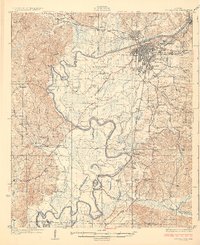 1926 Tuscaloosa1926 Print · USGSCentral Alabama's river-and-rail landscape is captured here during the mid-twenties, showcasing the growth of the University of Alabama and Tuscaloosa. Genealogists and historians can trace family-named sites like Carson Bluff Bend and rural landmarks such as Coker, Kings Ferry, and the Hull Consolidated School.3 unique versions available
 - 1953 Map of Birmingham, 1964 Print
 1953 Birmingham1964 Print · USGSCentral Alabama at mid-century shows a landscape defined by industrial expansion and the iron-rich ridges surrounding Birmingham. Researchers can trace the extensive rail networks of the L & N RR or locate historic federal sites like the Anniston Ordnance Depot.4 unique versions available
 - 1956 Map of Birmingham
 1956 Birmingham1956 Print · USGSCentral Alabama in the mid-fifties exhibits a landscape of growing cities and deep-rooted industrial corridors. Genealogists and historians can trace the development of suburban Mountain Brook or locate regional hubs like Sylacauga and Jasper.
 - 1957 Map of Birmingham
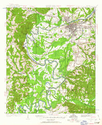
 1957 Birmingham1957 Print · USGSNorth-Central Alabama in the mid-fifties is an industrial powerhouse centered on the steel valleys and sprawling iron ridges. Genealogists and historians can trace the rail-linked growth of Birmingham and Tuscaloosa, or locate rural landmarks like Talladega College and the Anniston Ordnance Depot.
 - 1970 Map of Englewood, 1973 Print
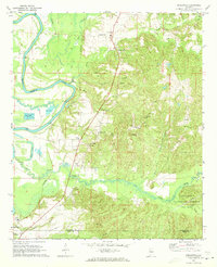 1970 Englewood1973 Print · USGSThe Black Warrior River valley and the Talladega National Forest meet in this 1970s survey of the Alabama borderlands. Researchers can trace rural lineages through numerous country churches like Zion Hope Ch or locate the ancient mounds at Mound State Mon.4 unique versions available
 - 1984 Map of Tuscaloosa, 1985 Print
 1984 Tuscaloosa1985 Print · USGSWest-central Alabama centers on the mid-1980s expansion of the university and the river economy. Genealogists and historians can trace small-town connections through Burchfield Store, North Johns, and the rail lines of the Southern railroad.2 unique versions available
 - 2002 Map of Englewood, 2003 Print
 2002 Englewood2003 Print · USGSTuscaloosa and Hale Counties appear in the early 21st century as a landscape of river bends and national forest. Researchers can trace the ancient earthworks at Mound State Mon, locate rural congregations like Zion Hope Ch, or find historical river access at Mcpherson Landing.
 - 2011 Map of Englewood, 2011 Print
 2011 Englewood2011 Print · USGSCovers Magnolia Park, including Tuscaloosa, Moundville, and other nearby areas
 - 2014 Map of Englewood, 2014 Print
 2014 Englewood2014 Print · USGSCovers Magnolia Park, including Tuscaloosa, Moundville, and other nearby areas
 - 2018 Map of Englewood, 2018 Print
 2018 Englewood2018 Print · USGSCovers Magnolia Park, including Tuscaloosa, Moundville, and other nearby areas
 - 2021 Map of Englewood, 2021 Print
 2021 Englewood2021 Print · USGSCovers Magnolia Park, including Tuscaloosa, Moundville, and other nearby areas
 - 2024 Map of Englewood, 2024 Print
 2024 Englewood2024 Print · USGSTuscaloosa and the Black Warrior River corridor come alive in this recent survey of the Alabama heartland. Researchers can trace the rural communities of Hull and Maxwell or locate ancestral burial sites like Hulls Cem and Big Sandy Cem.
End of results
Showing maps 1-13 of 13
Top cities near Magnolia Park
- Tuscaloosa historical maps
- Northport historical maps
- Holt historical maps
- Cottondale historical maps
- Moundville historical maps
- Brookwood historical maps
See more
Frequently asked questions
- What are the different types of historical maps available for Magnolia Park?
- What is the oldest map of Magnolia Park?
- Where can I purchase historical maps of Magnolia Park for my home or office?
- Where can I download high-res historical maps of Magnolia Park?
- Are there historical topographic maps available for Magnolia Park?
- Is there historical aerial imagery available for Magnolia Park?
- Where are historical maps of Magnolia Park sourced from?