1940s Maps of Tibbie, Alabama
Explore 2 historic maps of Tibbie from the 1940s. These maps offer a rare glimpse into what life looked like during the 1940s — showing old roads, neighborhoods, homes, and landmarks that have changed or disappeared over time.
Whether you're researching your family's past, planning a metal detecting trip, or studying how Tibbie's landscape evolved across the 1940s, these high-resolution maps are a powerful tool for exploring the history of this region.
- Focus on a specific era: All maps on this page are from the 1940s, giving you a focused view of this time period.
- See what’s changed: Compare century-old streets, trails, and buildings to today's modern landscape using overlays and satellite layers.
- Research with precision: Use these maps for genealogy, historical research, land use analysis, or educational projects.
- View, download, or print: Maps are fully viewable online in high resolution, and can be downloaded or printed for your own records.
Start exploring Tibbie's history through authentic maps from the 1940s. This is your window into the past.
Tibbie, AL maps
(2)- 1943 Map of McIntosh, 1972 Print
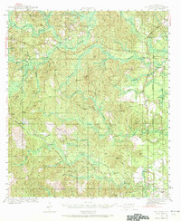 1943 McIntosh1972 Print · USGSMcIntosh and the Piney Woods of Washington County are shown here during the early 1940s, highlighting a landscape of timber, rails, and small settlements. Researchers can trace family roots through landmarks like Harris Cem, Fields Sch, and Pine Lodge Ch.
 - 1944 Map of McIntosh
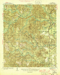 1944 McIntosh1944 Print · USGSWashington County during the early 1940s is captured here in detail, showing the rural communities of the Alabama pine belt. Genealogists can trace family landmarks like Harris Cem and the small country congregations at Bethel Ch and Pine Lodge Ch.2 unique versions available
End of results
Showing maps 1-2 of 2
Top cities near Tibbie
- Citronelle historical maps
- Mount Vernon historical maps
- Chatom historical maps
- State Line historical maps
- McIntosh historical maps
Frequently asked questions
- What are the different types of historical maps available for Tibbie?
- What is the oldest map of Tibbie?
- Where can I purchase historical maps of Tibbie for my home or office?
- Where can I download high-res historical maps of Tibbie?
- Are there historical topographic maps available for Tibbie?
- Is there historical aerial imagery available for Tibbie?
- Where are historical maps of Tibbie sourced from?