1900s (20th Century) Maps of Pine Apple, Alabama
Explore 8 historic maps of Pine Apple from the 1900s (20th Century). These maps offer a rare glimpse into what life looked like during the 1900s — showing old roads, neighborhoods, homes, and landmarks that have changed or disappeared over time.
Whether you're researching your family's past, planning a metal detecting trip, or studying how Pine Apple's landscape evolved across the 1900s, these high-resolution maps are a powerful tool for exploring the history of this region.
- Focus on a specific era: All maps on this page are from the 1900s, giving you a focused view of this time period.
- See what’s changed: Compare century-old streets, trails, and buildings to today's modern landscape using overlays and satellite layers.
- Research with precision: Use these maps for genealogy, historical research, land use analysis, or educational projects.
- View, download, or print: Maps are fully viewable online in high resolution, and can be downloaded or printed for your own records.
Start exploring Pine Apple's history through authentic maps from the 1900s. This is your window into the past.
Pine Apple, AL maps
(8)- 1953 Map of Andalusia, 1965 Print
 1953 Andalusia1965 Print · USGSSouth Alabama in the mid-twentieth century remains a land of pine forests and river-fed settlements. You can trace the vital rail corridors of the Louisville & Nashville and locate regional centers such as Andalusia, Brewton, and Monroeville.3 unique versions available
 - 1957 Map of Andalusia
 1957 Andalusia1957 Print · USGSSouthern Alabama in the mid-1950s was a landscape defined by timbered stretches and the rhythmic flow of the Alabama River. Researchers can trace the legacy of the rail era through the Central of Georgia tracks and the storied river bluffs at Choctaw Bluff.
 - 1981 Map of Oak Hill
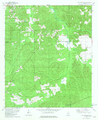
 1981 Oak Hill1981 Print · USGSWilcox County's rural character remains evident in the early 1980s, centered on the historic rail corridor of the Louisville and Nashville. Genealogists can trace family footprints through numerous country congregations and cemeteries like The Bear Creek Ch, McConico Cem, and St Paul Ch.
 - 1981 Map of Pine Apple North
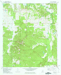
 1981 Pine Apple North1981 Print · USGSWilcox and Butler counties are captured here in the early 1980s, showing a rural landscape of timber and traditional crossroads. Trace community roots at Arkadelphia Ch, Jones High Sch, and the old settlement at Monterey.
 - 1981 Map of Mc Williams
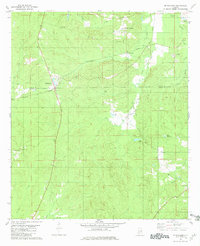 1981 Mc Williams1981 Print · USGSMonroe and Wilcox counties in the mid-seventies remain defined by timberlands and the legacy of the rail. You can trace early cemetery locations like Hopewell Cem, the path of the Louisville and Nashville Railroad Grade, and small communities like McWilliams and Schuster Springs.
 - 1981 Map of Pine Apple South
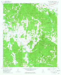
 1981 Pine Apple South1981 Print · USGSMonroe and Wilcox Counties appear here in the early eighties as the L & N railroad still shaped the rural landscape. Genealogists can locate family landmarks like Solomon Cem, Old Texas, and country churches such as Mount Zion Ch or Hopkins Chapel Cem.
 - 1986 Map of Monroeville
 1986 Monroeville1986 Print · USGSMonroe and Clarke counties are captured here in the mid-eighties, centered on the river valleys of the Alabama River and Tombigbee River. Genealogists and local historians can trace legacy settlements like Burnt Corn, Whatley, and the river site of Claiborne.2 unique versions available
 - 1986 Map of Greenville
 1986 Greenville1986 Print · USGSMid-century South Central Alabama comes alive in this survey of the creek-laced timberlands and rail-dependent towns between the Gulf Coastal Plain and the Piedmont. Researchers can trace family roots through numerous country landmarks like Magnolia Cem, Spring Hill Ch, and the Butler County State Wildlife Management Area.2 unique versions available
End of results
Showing maps 1-8 of 8
Top cities near Pine Apple
Frequently asked questions
- What are the different types of historical maps available for Pine Apple?
- What is the oldest map of Pine Apple?
- Where can I purchase historical maps of Pine Apple for my home or office?
- Where can I download high-res historical maps of Pine Apple?
- Are there historical topographic maps available for Pine Apple?
- Is there historical aerial imagery available for Pine Apple?
- Where are historical maps of Pine Apple sourced from?