Old Maps of Morzhovoi, False Pass for Hiking & Exploration
Hike through history with 4 historic maps of Morzhovoi. Explore old trails, ghost towns, and forgotten backroads — perfect for outdoor adventurers and local explorers.
- Rediscover forgotten places: Map out old mining camps, roads, and footpaths that no longer exist on modern maps.
- Layer with modern tools: Combine with LiDAR or satellite views to plan hikes through historical terrain.
- Made for exploration: Popular among hikers, overlanders, and local history lovers.
Use these maps to find adventure and explore the hidden past of Morzhovoi.
Morzhovoi, False Pass maps
(4)- 1949 Map of False Pass, 1956 Print
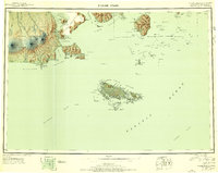 1949 False Pass1956 Print · USGSThe Aleutian landscape at the end of the 1940s is defined by the vital maritime passage between the Bering Sea and Pacific. Genealogists and researchers can trace remote coastal settlements at False Pass and Morzhovoi, or locate landmarks like Shishaldin Volcano and Sanak Harbor.6 unique versions available
 - 1950 Map of False Pass
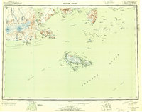 1950 False Pass1950 Print · USGSThe western Aleutians in the mid-twentieth century are captured here, centered on the vital waters of Isanotski Strait. Trace early settlements at False Pass and Morzhovoi alongside the massive heights of Shishaldin Volcano.2 unique versions available
 - 1995 Map of False Pass D-4
 1995 False Pass D-41995 Print · USGSThe Aleutian wilderness at the edge of the Bering Sea comes to life in this mid-nineties survey. Researchers can trace the coastal landforms of Unimak Island and locate remote features like Hotsprings Bay and Traders Cove.
 - 2020 Map of False Pass D-4 NW, 2020 Print
 2020 False Pass D-4 NW2020 Print · USGSThe remote coastline of the Alaska Peninsula is captured here in the contemporary era. Researchers can trace the layout of Morzhovoi and the coastal geography of Bechevin Bay, Traders Cove, and the heights of Traders Mtn.
End of results
Showing maps 1-4 of 4
Top cities near Morzhovoi
Frequently asked questions
- What are the different types of historical maps available for Morzhovoi?
- What is the oldest map of Morzhovoi?
- Where can I purchase historical maps of Morzhovoi for my home or office?
- Where can I download high-res historical maps of Morzhovoi?
- Are there historical topographic maps available for Morzhovoi?
- Is there historical aerial imagery available for Morzhovoi?
- Where are historical maps of Morzhovoi sourced from?