1900s (20th Century) Maps of Squaw Harbor, Alaska
Explore 3 historic maps of Squaw Harbor from the 1900s (20th Century). These maps offer a rare glimpse into what life looked like during the 1900s — showing old roads, neighborhoods, homes, and landmarks that have changed or disappeared over time.
Whether you're researching your family's past, planning a metal detecting trip, or studying how Squaw Harbor's landscape evolved across the 1900s, these high-resolution maps are a powerful tool for exploring the history of this region.
- Focus on a specific era: All maps on this page are from the 1900s, giving you a focused view of this time period.
- See what’s changed: Compare century-old streets, trails, and buildings to today's modern landscape using overlays and satellite layers.
- Research with precision: Use these maps for genealogy, historical research, land use analysis, or educational projects.
- View, download, or print: Maps are fully viewable online in high resolution, and can be downloaded or printed for your own records.
Start exploring Squaw Harbor's history through authentic maps from the 1900s. This is your window into the past.
Squaw Harbor, AK maps
(3)- 1953 Map of Port Moller
 1953 Port Moller1953 Print · USGSThe Alaska Peninsula during the early fifties reveals a maritime landscape of canneries, volcanic peaks, and strategic naval reserves. Researchers can trace remote Cabins, the Nelson Lagoon Cannery, and historical Ruins along the shores of Beaver Bay.3 unique versions available
 - 1963 Map of Port Moller A-2, 1967 Print
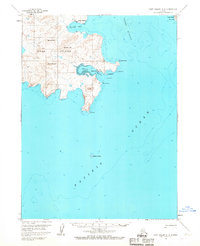 1963 Port Moller A-21967 Print · USGSUnga Island and the surrounding waters of the Shumagin Islands are detailed here in the early sixties, showing the vital maritime connection between remote coastal settlements. Researchers can trace the layout of the Unga townsite and Squaw Harbor, or locate the historic Apollo Mine near the island's interior peaks.3 unique versions available
 - 1988 Map of Port Moller, 1991 Print
 1988 Port Moller1991 Print · USGSThe remote reaches of the Alaska Peninsula and the Shumagin Islands are detailed here as they appeared in the late twentieth century. Researchers can trace the maritime hubs of Sand Point and Squaw Harbor or find isolated outposts like Nelson Lagoon Village and Miner.
End of results
Showing maps 1-3 of 3
Top cities near Squaw Harbor
Frequently asked questions
- What are the different types of historical maps available for Squaw Harbor?
- What is the oldest map of Squaw Harbor?
- Where can I purchase historical maps of Squaw Harbor for my home or office?
- Where can I download high-res historical maps of Squaw Harbor?
- Are there historical topographic maps available for Squaw Harbor?
- Is there historical aerial imagery available for Squaw Harbor?
- Where are historical maps of Squaw Harbor sourced from?