Old Maps of Squaw Harbor, Alaska for Academic Research
Study the evolution of Squaw Harbor with 5 high-resolution historic maps. Whether you're teaching, researching, or modeling changes in land use, these maps provide essential visual documentation of urban, environmental, and geographic change.
- Analyze long-term change: Track patterns in development, transportation, and natural features.
- Ideal for environmental or urban studies: Support academic projects with primary historical map data.
- Use in the classroom or lab: Educators and researchers rely on these maps to bring historical context to life.
These maps are a powerful tool for teaching, research, and visualizing how Squaw Harbor has changed over the decades.
Squaw Harbor, AK maps
(5)- 1953 Map of Port Moller
 1953 Port Moller1953 Print · USGSThe Alaska Peninsula during the early fifties reveals a maritime landscape of canneries, volcanic peaks, and strategic naval reserves. Researchers can trace remote Cabins, the Nelson Lagoon Cannery, and historical Ruins along the shores of Beaver Bay.3 unique versions available
 - 1963 Map of Port Moller A-2, 1967 Print
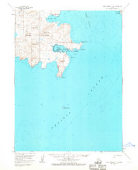 1963 Port Moller A-21967 Print · USGSUnga Island and the surrounding waters of the Shumagin Islands are detailed here in the early sixties, showing the vital maritime connection between remote coastal settlements. Researchers can trace the layout of the Unga townsite and Squaw Harbor, or locate the historic Apollo Mine near the island's interior peaks.3 unique versions available
 - 1988 Map of Port Moller, 1991 Print
 1988 Port Moller1991 Print · USGSThe remote reaches of the Alaska Peninsula and the Shumagin Islands are detailed here as they appeared in the late twentieth century. Researchers can trace the maritime hubs of Sand Point and Squaw Harbor or find isolated outposts like Nelson Lagoon Village and Miner.
 - 2020 Map of Port Moller A-2 NW, 2020 Print
 2020 Port Moller A-2 NW2020 Print · USGSCovers Squaw Harbor, including Unga, Aleutians East, and other nearby areas
 - 2023 Map of Port Moller A-2 NW, 2023 Print
 2023 Port Moller A-2 NW2023 Print · USGSUnga Island and the eastern Shumagin Islands are detailed in this recent survey, capturing the remote coastal geography of the Aleutians East. Trace the historic settlement of Unga near Delarof Harbor and explore landmarks like Apollo Mtn and Unga Cape.
End of results
Showing maps 1-5 of 5
Top cities near Squaw Harbor
Frequently asked questions
- What are the different types of historical maps available for Squaw Harbor?
- What is the oldest map of Squaw Harbor?
- Where can I purchase historical maps of Squaw Harbor for my home or office?
- Where can I download high-res historical maps of Squaw Harbor?
- Are there historical topographic maps available for Squaw Harbor?
- Is there historical aerial imagery available for Squaw Harbor?
- Where are historical maps of Squaw Harbor sourced from?