1970s Maps of Chandelle Acres, Anchorage
Explore 3 historic maps of Chandelle Acres from the 1970s. These maps offer a rare glimpse into what life looked like during the 1970s — showing old roads, neighborhoods, homes, and landmarks that have changed or disappeared over time.
Whether you're researching your family's past, planning a metal detecting trip, or studying how Chandelle Acres's landscape evolved across the 1970s, these high-resolution maps are a powerful tool for exploring the history of this region.
- Focus on a specific era: All maps on this page are from the 1970s, giving you a focused view of this time period.
- See what’s changed: Compare century-old streets, trails, and buildings to today's modern landscape using overlays and satellite layers.
- Research with precision: Use these maps for genealogy, historical research, land use analysis, or educational projects.
- View, download, or print: Maps are fully viewable online in high resolution, and can be downloaded or printed for your own records.
Start exploring Chandelle Acres's history through authentic maps from the 1970s. This is your window into the past.
Chandelle Acres, Anchorage maps
(3)- 1979 Map of Anchorage B-7 NE
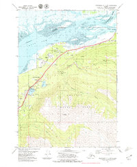 1979 Anchorage B-7 NE1979 Print · USGSThe Eklutna valley in the late seventies serves as a vital corridor where the rail line and highway meet the tidal flats. Researchers can locate the historic Eklutna settlement and its Cem, alongside local landmarks like Thunder Bird Falls and Eklutna Siding.3 unique versions available
 - 1979 Map of Anchorage, 1980 Print
 1979 Anchorage1980 Print · USGSThe Anchorage bowl and Matanuska Valley appear in the late seventies as the region's transportation and military infrastructure matured. Genealogists and historians can trace rail and road evolution through Wasilla, the Matanuska Branch line, and Jonesville.
 - 1979 Map of Anchorage B-7 NW, 1980 Print
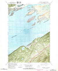 1979 Anchorage B-7 NW1980 Print · USGSThe Knik Arm shoreline comes into focus during the late seventies as the Birchwood community grows between military and state lands. Genealogists and locals can trace the Birchwood Loop Road, the Old Glenn Highway, and sites like Birchwood Camp.3 unique versions available
End of results
Showing maps 1-3 of 3
Frequently asked questions
- What are the different types of historical maps available for Chandelle Acres?
- What is the oldest map of Chandelle Acres?
- Where can I purchase historical maps of Chandelle Acres for my home or office?
- Where can I download high-res historical maps of Chandelle Acres?
- Are there historical topographic maps available for Chandelle Acres?
- Is there historical aerial imagery available for Chandelle Acres?
- Where are historical maps of Chandelle Acres sourced from?