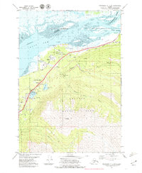
1979 Map of Anchorage B-7 NE
USGS Topo · Published 1979About this map
Eklutna and its surrounding river valley represent a critical junction of infrastructure and heritage in late-1970s Alaska. The landscape is defined by the corridor of The Alaska Railroad and the Glenn Highway, which run parallel along the base of the peaks within Chugach State Park. A small Cem and Eklutna Siding mark the local settlement, while recreational and youth sites like Chugach Camp and Camp Gorsuch are tucked near the shores of Mirror Lake and Edmonds Lake. To the north, the terrain gives way to the tidal environment of the Knik Arm, where the Matanuska River and Knik River converge across the expansive Duck Flats. The inclusion of various Gravel Pits and a Quarry indicates the active material extraction supporting regional growth during this era.
Find a feature on this map
35 named features on this map. Tap any name to fly to it.
Don’t see what you’re looking for? This feature index may not catch every label — zoom into the map to look around manually.
Map Details
Editions of this 1979 Anchorage B-7 NE Map
3 editions found
Other maps of this area

1950 · Anchorage C-7
USGS Topo · 1:63,360

1951 · Anchorage
USGS Topo · 1:250,000

1951 · Anchorage C-6
USGS Topo · 1:63,360

1951 · Anchorage C-7
USGS Topo · 1:63,360

1952 · Anchorage C-7
USGS Topo · 1:63,360

1960 · Anchorage B-7
USGS Topo · 1:63,360

1960 · Anchorage B-6
USGS Topo · 1:63,360

1962 · Anchorage
USGS Topo · 1:250,000

1979 · Anchorage B-6 NW
USGS Topo · 1:25,000

1979 · Anchorage B-7 SW
USGS Topo · 1:25,000