
1979 Map of Anchorage B-6 NW
USGS Topo · Published 1979About this map
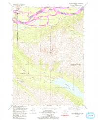
Knik River braided channels dominate the northern lowlands of this late 1970s Alaskan landscape, where infrastructure meets the wilderness of Chugach State Park. The map documents a critical transportation and utility corridor, featuring the intersection of The Alaska Railroad, the Glenn Highway, and the Old Glenn Highway. High above the valley floor, the twin summits of East Twin Peak and West Twin Peak overlook the glacial waters of Eklutna Lake. The presence of the Eklutna Powerhouse, a Spillway, and a Landing Strip near the lake's western edge indicates the importance of this area for regional power generation and backcountry access. Local landmarks like Goat Lake and Lake Barbara are reached only by a Jeep Trail or Pack Trail, highlighting the area's transition from developed thoroughfares to the interior backcountry.
Find a feature on this map
24 named features on this map. Tap any name to fly to it.
Don’t see what you’re looking for? This feature index may not catch every label — zoom into the map to look around manually.
Map Details
Editions of this 1979 Anchorage B-6 NW Map
2 editions found
Other maps of this area

1950 · Anchorage C-7
USGS Topo · 1:63,360

1951 · Anchorage
USGS Topo · 1:250,000

1951 · Anchorage C-6
USGS Topo · 1:63,360

1951 · Anchorage C-7
USGS Topo · 1:63,360

1952 · Anchorage C-7
USGS Topo · 1:63,360

1960 · Anchorage B-7
USGS Topo · 1:63,360

1960 · Anchorage B-6
USGS Topo · 1:63,360

1962 · Anchorage
USGS Topo · 1:250,000
1979 · Anchorage B-7 SE
USGS Topo · 1:25,000
1979 · Anchorage B-7 NE
USGS Topo · 1:25,000