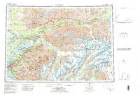
1962 Map of Anchorage
USGS Topo · Published 1966About this map
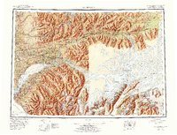
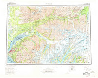
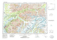
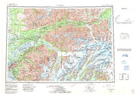
Anchorage and its surrounding borough serve as the hub for this mid-century survey, illustrating the critical transportation and military infrastructure of south-central Alaska. The Alaska Railroad and the Glenn Highway connect the urban center to the industrial and agricultural corridors of the Knik River and Matanuska River valleys. To the north, the coal-mining heritage of the region is evident in the rail spurs serving Jonesville and Eska, while the Talkeetna Mountains and Chugach Mountains dominate the terrain with massive ice fields like the Matanuska Glacier. The map meticulously details the expansion of Elmendorf Air Force Base and the Fort Richardson Military Reservation, including the Fort Richardson Cem. Local landmarks such as the Watertower Inn and Meekins Roadhouse provide important reference points for researchers tracking the development of roadside commerce during this era of growth.
Find a feature on this map
195 named features on this map. Tap any name to fly to it.
Don’t see what you’re looking for? This feature index may not catch every label — zoom into the map to look around manually.
Map Details
Editions of this 1962 Anchorage Map
6 editions found
Historical Maps of Anchorage Through Time
3 maps found