
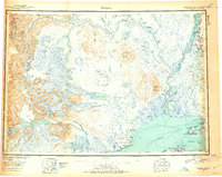
1949 Map of Tyonek
USGS Topo · Published 1954About this map
Tyonek and the Moquawkie Indian Reservation anchor the northern reaches of Cook Inlet in this mid-century reconnaissance of the Alaska wilderness. The landscape is defined by the massive glacial systems of the Alaska Range, including the Triumvirate Glacier, Hayes Glaciers, and Capps Glacier, which feed into the intricate river networks of the Skwentna River and Yentna River. In the east, the Alaska Railroad provides a corridor of activity through Willow and Kashwitna, contrasting with the more isolated outposts and abandoned sites like McDougall. Volcanic features such as Mt Spurr and Crater Peak overlook a terrain where transportation relies heavily on water routes and the abandoned trail networks that once linked these remote settlements before modern infrastructure reached the interior.
Find a feature on this map
121 named features on this map. Tap any name to fly to it.
Don’t see what you’re looking for? This feature index may not catch every label — zoom into the map to look around manually.
Map Details
Editions of this 1949 Tyonek Map
2 editions found
Other maps of this area

1944 · Kenai
USGS Topo · 1:250,000

1946 · Lake Clark
USGS Topo · 1:250,000

1949 · McGrath
USGS Topo · 1:250,000

1949 · Anchorage D-8
USGS Topo · 1:63,360

1950 · Kenai
USGS Topo · 1:250,000

1950 · McGrath
USGS Topo · 1:250,000

1950 · Talkeetna Mountains
USGS Topo · 1:250,000

1950 · Talkeetna
USGS Topo · 1:250,000

1950 · Anchorage C-8
USGS Topo · 1:63,360

1950 · Talkeetna Mountains A-6
USGS Topo · 1:63,360