1965 Map of Tyonek
USGS Topo · Published 1965About this map
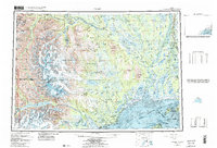
Mount Spurr and the glaciated peaks of the Tordrillo Mountains dominate this mid-century survey of the western shore of Cook Inlet. The map illustrates a landscape of profound topographical transition, where the massive ice flows of Triumvirate Glacier and Blockade Glacier give way to the expansive Susitna Flats and the braiding channels of the Susitna River. Coastal settlements and logistical hubs are documented, including the Moquawkie (Tyonek) Indian Reservation, Old Tyonek, and the village of Beluga. To the east, the infrastructure of the rail era is evident along The Alaska Railroad, which services interior points like Caswell. The map also captures significant territorial markers such as the Fort Richardson Military Reservation and the Kenai National Moose Range at the edge of the Kenai Peninsula.
Find a feature on this map
84 named features on this map. Tap any name to fly to it.
Don’t see what you’re looking for? This feature index may not catch every label — zoom into the map to look around manually.
Map Details
Editions of this 1965 Tyonek Map
This is the sole edition of this map. No revisions or reprints were ever made.
Historical Maps of Willow Through Time
4 maps found