Old Maps of Willow, Alaska
Explore 10 old maps of Willow, spanning from 1949 to today. These high-resolution historic maps reveal how streets, neighborhoods, landmarks, and natural features evolved over time — perfect for genealogy, metal detecting, research, and local history exploration.
What you can do with these maps:
- See how Willow changed over time: Compare historical maps to modern-day views to trace roads, homesites, rail lines & more.
- View detailed metadata: Each map includes creators, publishers, year, scale, and archive source.
- Overlay maps with satellite & LiDAR: Visualize the past alongside modern tools to explore terrain & human change.
- Trusted historical sources: Maps sourced from the USGS, Library of Congress, and other archives.
- Access maps your way: View online, download high-res files, or order prints for personal or research use.
Start exploring old maps of Willow to uncover forgotten places, hidden landmarks, and the deep history beneath your feet.
Willow, AK maps
(10)- 1949 Map of Tyonek, 1954 Print
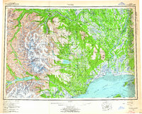
 1949 Tyonek1954 Print · USGSUpper Cook Inlet and the Alaska Range appear here in the mid-twentieth century as a landscape of massive glaciers and river-bound outposts. Researchers can trace the early rail corridor through Willow, locate the Moquawkie Indian Reservation, and find the site of McDougall.2 unique versions available
 - 1951 Map of Tyonek
 1951 Tyonek1951 Print · USGSThe Cook Inlet and the Alaska Range come into focus in the early fifties as the region's rail and trail networks evolved. Trace the path of the Alaska Railroad through Willow or locate the historic Iditarod Trail near Susitna.
 - 1952 Map of Tyonek C-1
 1952 Tyonek C-11952 Print · USGSThe Matanuska-Susitna region comes into focus during the early fifties, showing the frontier development of the rail-and-air network. Researchers can trace the early layout of Willow and locate the Willow Station Airstrip near Willow Lake.
 - 1958 Map of Tyonek C-1, 1962 Print
 1958 Tyonek C-11962 Print · USGSThe Matanuska-Susitna Valley is captured here in the late fifties, showing a wilderness being opened by The Alaska Railroad. Researchers can locate remote Cabins, the early Willow Station Airstrip, and inland access points along the Tractor Trail.3 unique versions available
 - 1958 Map of Tyonek, 1964 Print
 1958 Tyonek1964 Print · USGSUpper Cook Inlet and the Susitna River valley are shown in the late fifties, capturing a period of transition between coastal village life and inland development. Researchers can trace the Winter Trail and Tractor Trail paths to settlements like Alexander and Susitna.6 unique versions available
 - 1965 Map of Tyonek
 1965 Tyonek1965 Print · USGSUpper Cook Inlet in the mid-sixties reveals a landscape defined by massive glaciers and the early footprints of coastal settlements. Trace the rail-and-river network from The Alaska Railroad to isolated outposts like Old Tyonek, Ladd, and the Moquawkie (Tyonek) Indian Reservation.
 - 1979 Map of Tyonek C-1 NE, 1981 Print
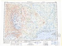
 1979 Tyonek C-1 NE1981 Print · USGSThe Matanuska-Susitna interior comes into focus during the late 1970s as the railroad and recreation lands intersect. Genealogists and historians can trace the growth of Willow, follow the Alaska Railroad south to Whites Crossing, and locate remote camps in the Nancy Lake State Recreation Area.2 unique versions available
 - 1993 Map of Tyonek C-1, 2002 Print
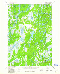
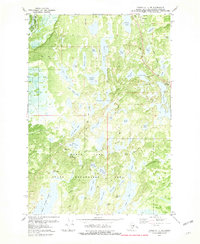
 1993 Tyonek C-12002 Print · USGSThe Susitna Valley in the early 1990s shows a landscape of wilderness transit, from the historic Iditarod Trail to the Parks Highway. Researchers can trace remote Cabins along the Deshka River and the development surrounding Willow Airport.
 - 2016 Map of Tyonek C-1 NE, 2016 Print
 2016 Tyonek C-1 NE2016 Print · USGSCovers Willow, including Willow Lake, Matanuska-Susitna, and other nearby areas
 - 2023 Map of Tyonek C-1 NE, 2023 Print
 2023 Tyonek C-1 NE2023 Print · USGSIn the wilderness around Willow, this recent survey documents a landscape where aviation and water travel are the primary modes of movement. Researchers can trace remote airstrips like the Minuteman Strip and the elaborate James Lake Loop Canoe Tri through the lakes of the Matanuska-Susitna area.
End of results
Showing maps 1-10 of 10
Top cities near Willow
Frequently asked questions
- What are the different types of historical maps available for Willow?
- What is the oldest map of Willow?
- Where can I purchase historical maps of Willow for my home or office?
- Where can I download high-res historical maps of Willow?
- Are there historical topographic maps available for Willow?
- Is there historical aerial imagery available for Willow?
- Where are historical maps of Willow sourced from?