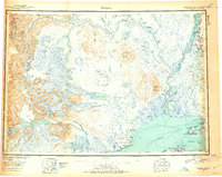
1949 Map of Tyonek
USGS Topo · Published 1954About this map
The Moquawkie Indian Reservation and the coastal settlement of Tyonek anchor this 1949 survey of the northern Cook Inlet region. Before the extensive development of the later 20th century, this area relied on air and water access, evidenced by the Tyonek Airstrip, Grants Airstrip, and Skwentna Airstrip. The interior landscape is dominated by the glacial systems of the Alaska Range, including the massive Triumvirate Glacier and Hayes Glacier, which feed into the complex river networks of the Susitna River and Beluga Lake. The historic Iditarod Trail is visible cutting through the northwest, while the Alexander Trail provides a terrestrial link further south. Key topographical landmarks such as Mt Spurr and its Crater Peak stand as prominent features overlooking the glacial valleys and the expansive waters of the Cook Inlet.
Find a feature on this map
108 named features on this map. Tap any name to fly to it.
Don’t see what you’re looking for? This feature index may not catch every label — zoom into the map to look around manually.
Map Details
Editions of this 1949 Tyonek Map
2 editions found
Other maps of this area

1944 · Kenai
USGS Topo · 1:250,000

1946 · Lake Clark
USGS Topo · 1:250,000

1949 · Tyonek
USGS Topo · 1:250,000

1949 · McGrath
USGS Topo · 1:250,000

1949 · Anchorage D-8
USGS Topo · 1:63,360

1950 · Kenai
USGS Topo · 1:250,000

1950 · McGrath
USGS Topo · 1:250,000

1950 · Talkeetna Mountains
USGS Topo · 1:250,000

1950 · Talkeetna
USGS Topo · 1:250,000

1950 · Anchorage C-8
USGS Topo · 1:63,360