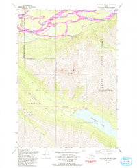
1979 Map of Anchorage B-6 NW
USGS Topo · Published 1993About this map
The braided channels of the Knik River dominate the northern landscape of this region, marking a sharp transition into the high elevations of Chugach State Park. This 1970s record, updated in the early 1990s, documents the infrastructure supporting the local hydro-economy, most notably the Eklutna Powerhouse and the extensive Eklutna Lake reservoir system. The map details the passage through the mountains via the Eklutna Pack Trail and tracks the development along the Glenn Highway and the Old Glenn Highway. High-altitude landmarks like East Twin Peak and West Twin Peak overlook a network of glacial waters including Goat Lake and Thechkatnu Creek. The boundary between the Municipality of Anchorage and Matanuska-Susitna Borough cuts directly through this wilderness, highlighting the area's role as a vital corridor between the Anchorage basin and the interior.
Find a feature on this map
20 named features on this map. Tap any name to fly to it.
Don’t see what you’re looking for? This feature index may not catch every label — zoom into the map to look around manually.
Map Details
Editions of this 1979 Anchorage B-6 NW Map
2 editions found
Other maps of this area

1950 · Anchorage C-7
USGS Topo · 1:63,360

1951 · Anchorage
USGS Topo · 1:250,000

1951 · Anchorage C-6
USGS Topo · 1:63,360

1951 · Anchorage C-7
USGS Topo · 1:63,360

1952 · Anchorage C-7
USGS Topo · 1:63,360

1960 · Anchorage B-7
USGS Topo · 1:63,360

1960 · Anchorage B-6
USGS Topo · 1:63,360

1962 · Anchorage
USGS Topo · 1:250,000

1979 · Anchorage B-6 NW
USGS Topo · 1:25,000
1979 · Anchorage B-7 SE
USGS Topo · 1:25,000