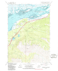
1979 Map of Anchorage B-7 NE
USGS Topo · Published 1987About this map
The Knik Arm shoreline meets the rising peaks of Chugach State Park in this 1970s record of the Cook Inlet region. This map documents a critical transportation corridor where The Alaska Railroad and the Glenn Highway parallel the coast, serving the village of Eklutna and the nearby Eklutna Siding. The landscape is defined by the transition from the marshy Duck Flats at the mouth of the Knik River to the high elevation of Mount Eklutna. Recreational and community sites are well-established by this era, including Mirror Lake State Wayside Park, Camp Gorsuch, and Chugach Camp. Notable industrial markers like a Quarry, several Gravel Pits, and a Substa indicate the infrastructure supporting the growth of the Anchorage Municipality. The interior is marked by the course of the Eklutna River and the secluded Thunder Bird Falls.
Find a feature on this map
36 named features on this map. Tap any name to fly to it.
Don’t see what you’re looking for? This feature index may not catch every label — zoom into the map to look around manually.
Map Details
Editions of this 1979 Anchorage B-7 NE Map
3 editions found
Other maps of this area

1950 · Anchorage C-7
USGS Topo · 1:63,360

1951 · Anchorage
USGS Topo · 1:250,000

1951 · Anchorage C-6
USGS Topo · 1:63,360

1951 · Anchorage C-7
USGS Topo · 1:63,360

1952 · Anchorage C-7
USGS Topo · 1:63,360

1960 · Anchorage B-7
USGS Topo · 1:63,360

1960 · Anchorage B-6
USGS Topo · 1:63,360

1962 · Anchorage
USGS Topo · 1:250,000

1979 · Anchorage B-6 NW
USGS Topo · 1:25,000

1979 · Anchorage B-7 SW
USGS Topo · 1:25,000