1990s Maps of Discovery Heights, Anchorage
Explore 2 historic maps of Discovery Heights from the 1990s. These maps offer a rare glimpse into what life looked like during the 1990s — showing old roads, neighborhoods, homes, and landmarks that have changed or disappeared over time.
Whether you're researching your family's past, planning a metal detecting trip, or studying how Discovery Heights's landscape evolved across the 1990s, these high-resolution maps are a powerful tool for exploring the history of this region.
- Focus on a specific era: All maps on this page are from the 1990s, giving you a focused view of this time period.
- See what’s changed: Compare century-old streets, trails, and buildings to today's modern landscape using overlays and satellite layers.
- Research with precision: Use these maps for genealogy, historical research, land use analysis, or educational projects.
- View, download, or print: Maps are fully viewable online in high resolution, and can be downloaded or printed for your own records.
Start exploring Discovery Heights's history through authentic maps from the 1990s. This is your window into the past.
Discovery Heights, Anchorage maps
(2)- 1993 Map of Anchorage A-8 SW
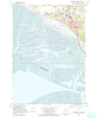 1993 Anchorage A-8 SW1993 Print · USGSSouth Anchorage in the early nineties reveals a landscape of growing residential neighborhoods meeting the tidal mudflats of the Turnagain Arm. Trace local landmarks like the Evergreen Memorial Cem, Potter Marsh, and the Klatt settlement.
 - 1994 Map of Anchorage A-8, 2002 Print
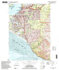 1994 Anchorage A-82002 Print · USGSAnchorage during the mid-nineties shows a city defined by its military bases, university campuses, and bustling aviation hubs. Researchers can trace the development of suburban neighborhoods and major landmarks like the Diamond Center Shopping Mall, Wilson Village, and the Fort Richardson Cem.
End of results
Showing maps 1-2 of 2
Frequently asked questions
- What are the different types of historical maps available for Discovery Heights?
- What is the oldest map of Discovery Heights?
- Where can I purchase historical maps of Discovery Heights for my home or office?
- Where can I download high-res historical maps of Discovery Heights?
- Are there historical topographic maps available for Discovery Heights?
- Is there historical aerial imagery available for Discovery Heights?
- Where are historical maps of Discovery Heights sourced from?