Old Maps of Anderson, Alaska for Metal Detecting
Plan your next treasure hunt with 13 historic maps of Anderson. Find old homesites, ghost towns, trails, and gathering spots that may be lost to time — perfect for identifying promising metal detecting locations.
- Locate forgotten sites: Uncover places like long-lost settlements, abandoned rail lines, or gathering spots.
- Plan better hunts: Use map overlays combined with LiDAR or satellite views to narrow in on historically rich areas.
- Made for detectorists: Thousands of hobbyists use these maps to discover relics, coins, and hidden history.
Use these historic maps to boost your research and find new opportunities beneath the surface of Anderson.
Anderson, AK maps
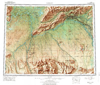
(13)- 1949 Map of Fairbanks B-5, 1958 Print
 1949 Fairbanks B-51958 Print · USGSThe braided river valleys and military outposts of Interior Alaska are captured here just before statehood. Researchers can trace the path of the Alaska Railroad past the Clear Air Force Auxiliary Field and the small siding at Julius.
 - 1949 Map of Fairbanks B-4, 1963 Print
 1949 Fairbanks B-41963 Print · USGSThe interior wilderness along the Tatlanika River is captured here just after the war. Local historians can trace the early Clear Military Reservation Boundary and follow the route of an old Winter Trail.5 unique versions available
 - 1950 Map of Fairbanks, 1955 Print
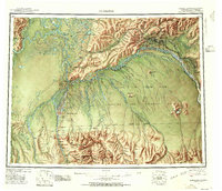 1950 Fairbanks1955 Print · USGSMid-century Interior Alaska centers on the growing hub of Fairbanks and the massive military infrastructure that reshaped the region. Trace the path of the Alaska Railroad past remote stops like Nenana and Dunbar, or locate early aviation and mining landmarks such as Weeks Field and various Placer Mine sites.2 unique versions available
 - 1950 Map of Fairbanks B-5, 1967 Print
 1950 Fairbanks B-51967 Print · USGSInterior Alaska's river systems and early rail infrastructure are documented here during the mid-century transition. Researchers can trace the Alaska Railroad past Anderson to find historic sites like Shores Landing and Squaw Pants Crossing.
 - 1951 Map of Fairbanks B-5
 1951 Fairbanks B-51951 Print · USGSThe interior Alaskan wilderness near Fairbanks is captured here in the early fifties, showing the vital intersection of rail and river. You can trace the Alaska Railroad past the stations at Julius and Clear or follow the Sled Trail through the lowlands.2 unique versions available
 - 1951 Map of Fairbanks
 1951 Fairbanks1951 Print · USGSThe Interior of Alaska at the height of the mid-century military buildup shows a landscape of strategic airfields and remote river settlements. Researchers can trace the path of the Alaska Railroad and locate cold-war era sites like Ladd Air Force Base and Minto.2 unique versions available
 - 1952 Map of Fairbanks B-4
 1952 Fairbanks B-41952 Print · USGSInterior Alaska in the early fifties shows a landscape shaped by military expansion and subarctic transit. Researchers can trace the sprawling Ladd Air Force Base Bombing and Gunnery Range and an old Sled Road.2 unique versions available
 - 1952 Map of Fairbanks, 1958 Print
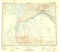
 1952 Fairbanks1958 Print · USGSAlaska's interior undergoes a post-war transformation as military installations and rail lines expand across the Tanana Valley. Genealogists and historians can trace the early layout of North Pole, the operations at Ester, and the course of The Alaska Railroad.6 unique versions available
 - 1956 Map of Fairbanks, 1978 Print
 1956 Fairbanks1978 Print · USGSIn the mid-twentieth century, the Fairbanks region emerged as a critical Cold War interior hub. Researchers can trace the expansion of Fairbanks, the rail yards of The Alaska Railroad, and military landmarks like Eielson AFB.3 unique versions available
 - 1964 Map of Fairbanks
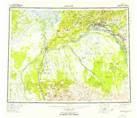
 1964 Fairbanks1964 Print · USGSInterior Alaska in the mid-1960s centered on the growing hub of Fairbanks and its strategic military and rail connections. Genealogists and historians can trace the paths of The Alaska Railroad through Nenana or locate Placer Mines near Murphy Dome and Ester.
 - 2013 Map of Fairbanks B-4 SW, 2013 Print
 2013 Fairbanks B-4 SW2013 Print · USGSThe border of the Yukon-Koyukuk and Denali boroughs comes into focus in this 2013 survey of the Alaskan interior. Researchers and genealogists can trace the residential area of Clear Mews and follow the seasonal route of the Sled Rd as it nears the Totatlanika River.
 - 2013 Map of Fairbanks B-5 SW, 2013 Print
 2013 Fairbanks B-5 SW2013 Print · USGSThe Denali and Yukon-Koyukuk borderlands are defined by the winding course of the river in this early 2010s survey. Researchers can trace the braided water patterns of Seventeenmile Slough and the isolated stretches of Bush Rd and Sled Rd.
 - 2013 Map of Fairbanks B-5 SE, 2013 Print
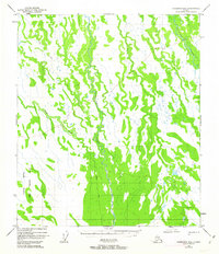
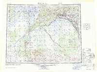
 2013 Fairbanks B-5 SE2013 Print · USGSThe town of Anderson and the surrounding interior landscape are captured here in the early twenty-first century. Researchers can trace the layout of the Clear Air Force Sta and local infrastructure like the PO and the Clear Airport.
End of results
Showing maps 1-13 of 13
Top cities near Anderson
Frequently asked questions
- What are the different types of historical maps available for Anderson?
- What is the oldest map of Anderson?
- Where can I purchase historical maps of Anderson for my home or office?
- Where can I download high-res historical maps of Anderson?
- Are there historical topographic maps available for Anderson?
- Is there historical aerial imagery available for Anderson?
- Where are historical maps of Anderson sourced from?