Old Maps of Denali Canyon, Denali for Hiking & Exploration
Hike through history with 6 historic maps of Denali Canyon. Explore old trails, ghost towns, and forgotten backroads — perfect for outdoor adventurers and local explorers.
- Rediscover forgotten places: Map out old mining camps, roads, and footpaths that no longer exist on modern maps.
- Layer with modern tools: Combine with LiDAR or satellite views to plan hikes through historical terrain.
- Made for exploration: Popular among hikers, overlanders, and local history lovers.
Use these maps to find adventure and explore the hidden past of Denali Canyon.
Denali Canyon, Denali maps
(6)- 1950 Map of Healy C-4, 1963 Print
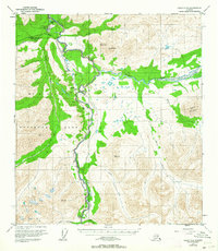 1950 Healy C-41963 Print · USGSThe Alaska interior at the start of the 1950s reveals the early development of Mt McKinley National Park and its surrounding river valleys. Trace the Alaska Railroad as it services McKinley Park and the settlement at Carlo along the Nenana River.6 unique versions available
 - 1951 Map of Healy
 1951 Healy1951 Print · USGSThe Alaska interior during the early fifties reveals a landscape shaped by the Alaska Railroad and the mining of the Alaska Range. Trace early settlements and infrastructure like Suntrana, the Dunkle Coal Mine, and the McKinley Park Airstrip at the edge of the wilderness.5 unique versions available
 - 1952 Map of Healy C-4
 1952 Healy C-41952 Print · USGSDenali's interior during the early fifties reveals a landscape shaped by the rail-and-river corridor through the Alaska Range. Researchers can trace the legacy of the wilderness boundary and early park infrastructure at McKinley Park, or locate the Coal Mine (Aband) and rail stops at Yanert and Carlo.2 unique versions available
 - 1956 Map of Healy, 1966 Print
 1956 Healy1966 Print · USGSThe interior of Alaska is shown during a period of industrial and recreational expansion in the mid-fifties. Genealogists and historians can trace the Alaska Railroad corridor through Healy and mining sites like Usibelli Mine.4 unique versions available
 - 2016 Map of Healy C-4 NW, 2016 Print
 2016 Healy C-4 NW2016 Print · USGSCovers Denali Canyon, including Denali, United States, and other nearby areas
 - 2019 Map of Healy C-4 NW, 2019 Print
 2019 Healy C-4 NW2019 Print · USGSDenali’s gateway region in the early twenty-first century reveals a landscape defined by its river corridors and a maturing trail system. Trace the footpaths around Horseshoe Lake, locate the McKinley National Park Airport, and follow the winding course of the Nenana River.
End of results
Showing maps 1-6 of 6
Frequently asked questions
- What are the different types of historical maps available for Denali Canyon?
- What is the oldest map of Denali Canyon?
- Where can I purchase historical maps of Denali Canyon for my home or office?
- Where can I download high-res historical maps of Denali Canyon?
- Are there historical topographic maps available for Denali Canyon?
- Is there historical aerial imagery available for Denali Canyon?
- Where are historical maps of Denali Canyon sourced from?