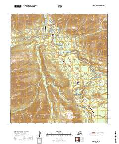
2019 Map of Healy C-4 NW
USGS Topo · Published 2019About this map
Denali National Park serves as the focal point of this 2019 survey, illustrating the complex intersection of federal land management and transport infrastructure near the park's primary entrance. The Nenana River carves a dominant path through the eastern half of the sheet, joined by the Yanert Fork and several smaller drainages like Riley Cr and Montana Cr. The map details a sophisticated network of recreational paths including the Horseshoe Lake Trail, McKinley Station Trail, and Triple Lakes Trail, which provide access to interior features like Horseshoe Lake and the Triple Lakes system.
Find a feature on this map
33 named features on this map. Tap any name to fly to it.
Don’t see what you’re looking for? This feature index may not catch every label — zoom into the map to look around manually.
Map Details
Editions of this 2019 Healy C-4 NW Map
This is the sole edition of this map. No revisions or reprints were ever made.
Other maps of this area

1950 · Healy D-4
USGS Topo · 1:63,360

1950 · Healy C-4
USGS Topo · 1:63,360

1951 · Healy
USGS Topo · 1:250,000

1951 · Healy D-5
USGS Topo · 1:63,360

1952 · Healy D-5
USGS Topo · 1:63,360

1952 · Healy C-5
USGS Topo · 1:63,360
1952 · Healy C-4
USGS Topo · 1:63,360
1952 · Healy D-4
USGS Topo · 1:63,360

1953 · Healy C-5
USGS Topo · 1:63,360

1956 · Healy
USGS Topo · 1:250,000