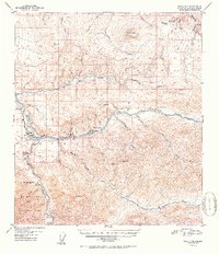
1952 Map of Healy D-4
USGS Topo · Published 1952About this map
The Alaska Railroad corridor serves as the industrial spine of this interior Alaskan landscape, following the course of the Nenana River through a region defined by coal extraction and rugged topography. At the heart of the activity is the Usibelli Coal Mine, situated along Healy Creek between the rail-accessible settlements of Healy and Suntrana. This 1952 edition illustrates a moment of high industrial utility, showing multiple airstrips and railroad mile markers such as Mile 360 and Mile 355 that anchored these remote communities to the outside world.
Find a feature on this map
54 named features on this map. Tap any name to fly to it.
Don’t see what you’re looking for? This feature index may not catch every label — zoom into the map to look around manually.
Map Details
Editions of this 1952 Healy D-4 Map
2 editions found
Other maps of this area

1949 · Healy C-3
USGS Topo · 1:63,360

1950 · Fairbanks
USGS Topo · 1:250,000

1950 · Fairbanks A-5
USGS Topo · 1:63,360

1950 · Healy D-4
USGS Topo · 1:63,360

1950 · Healy C-4
USGS Topo · 1:63,360

1950 · Fairbanks A-4
USGS Topo · 1:63,360

1950 · Fairbanks A-3
USGS Topo · 1:63,360

1950 · Healy D-3
USGS Topo · 1:63,360

1951 · Healy
USGS Topo · 1:250,000

1951 · Fairbanks
USGS Topo · 1:250,000