
1950 Map of Fairbanks A-3
USGS Topo · Published 1964About this map
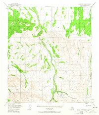
Tatlanika Creek and its many tributaries form the backbone of this interior Alaskan landscape, mapped from 1949 aerial photography and 1950 field annotations. The drainage network includes family-named and prospector-named waters such as Saint George Creek, Roosevelt Creek, and Hearst Creek, highlighting the era's mining and exploration activity. High elevations are marked by survey points like Vabm Murphy 4330, while the lower valley floors contain evidence of remote infrastructure. A solitary Landing Strip and a Sled Road serve as the primary transport links in a region where travel depended on seasonal conditions. Evidence of small-scale resource extraction is visible through the presence of a Placer Mine near Gold King Creek and a Ditch system. A single Cabin label suggests the isolated nature of human settlement in this part of the Fairbanks Meridian during the mid-twentieth century.
Find a feature on this map
21 named features on this map. Tap any name to fly to it.
Don’t see what you’re looking for? This feature index may not catch every label — zoom into the map to look around manually.
Map Details
Editions of this 1950 Fairbanks A-3 Map
4 editions found
Other maps of this area

1949 · Fairbanks B-4
USGS Topo · 1:63,360

1949 · Fairbanks B-3
USGS Topo · 1:63,360

1949 · Fairbanks A-2
USGS Topo · 1:63,360

1950 · Fairbanks
USGS Topo · 1:250,000

1950 · Healy D-4
USGS Topo · 1:63,360

1950 · Fairbanks A-4
USGS Topo · 1:63,360

1950 · Fairbanks B-2
USGS Topo · 1:63,360

1950 · Healy D-3
USGS Topo · 1:63,360

1951 · Healy
USGS Topo · 1:250,000
1951 · Fairbanks B-2
USGS Topo · 1:63,360