
1949 Map of Fairbanks B-3
USGS Topo · Published 1967About this map
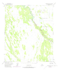
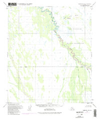
Wood River winds southward through this interior Alaskan landscape, defining a complex corridor of wetlands and shifting channels as it appeared in the mid-20th century. The territory is largely defined by massive federal land tracts, specifically the Air Force Range and the Military Res Bdy, which occupy the eastern half of the map. To the west, the drainage of Tatlanika Creek cuts across an unsurveyed expanse of the Fairbanks Meridian. The map captures a transition in local governance within the Fairbanks North Star Borough, where the wilderness remains largely roadless. Prospectors and geologists would note the presence of Bonnifield Gold King Creek in the southeast, a name hinting at the region's mineral history. Small water bodies like Blair Lake and the elevated Buttes provide the few fixed landmarks in a terrain dominated by Fish Creek and Saint George Creek.
Find a feature on this map
12 named features on this map. Tap any name to fly to it.
Don’t see what you’re looking for? This feature index may not catch every label — zoom into the map to look around manually.
Map Details
Editions of this 1949 Fairbanks B-3 Map
3 editions found
Other maps of this area

1949 · Fairbanks C-2
USGS Topo · 1:63,360

1949 · Fairbanks B-4
USGS Topo · 1:63,360

1949 · Fairbanks A-2
USGS Topo · 1:63,360

1950 · Fairbanks
USGS Topo · 1:250,000

1950 · Fairbanks C-3
USGS Topo · 1:63,360

1950 · Fairbanks C-4
USGS Topo · 1:63,360

1950 · Fairbanks A-4
USGS Topo · 1:63,360

1950 · Fairbanks A-3
USGS Topo · 1:63,360

1950 · Fairbanks B-2
USGS Topo · 1:63,360
1951 · Fairbanks B-2
USGS Topo · 1:63,360