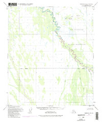
1949 Map of Fairbanks B-3
USGS Topo · Published 1988About this map
Wood River meanders through the heart of this Alaskan interior landscape, defining the transition between the Fairbanks North Star Borough and the Denali Borough. Much of the northern terrain is occupied by the Fort Wainwright Military Reservation, where the river's winding path is closely traced by the military boundary. To the south, the drainage network becomes more complex, featuring numerous tributaries such as Tatlanika Creek and the curiously named Bonnifield Gold King Creek. The topography is punctuated by elevations like the Buttes and Butte West, which serve as prominent landmarks in an otherwise low-lying expanse of wetlands and stream valleys. This 1949 survey, updated with 1972 aerial photography, documents the remote nature of this region before significant modern development, focusing on the essential hydrological and administrative lines of the territory.
Find a feature on this map
13 named features on this map. Tap any name to fly to it.
Don’t see what you’re looking for? This feature index may not catch every label — zoom into the map to look around manually.
Map Details
Editions of this 1949 Fairbanks B-3 Map
3 editions found
Other maps of this area

1949 · Fairbanks C-2
USGS Topo · 1:63,360

1949 · Fairbanks B-4
USGS Topo · 1:63,360

1949 · Fairbanks B-3
USGS Topo · 1:63,360

1949 · Fairbanks A-2
USGS Topo · 1:63,360

1950 · Fairbanks
USGS Topo · 1:250,000

1950 · Fairbanks C-3
USGS Topo · 1:63,360

1950 · Fairbanks C-4
USGS Topo · 1:63,360

1950 · Fairbanks A-4
USGS Topo · 1:63,360

1950 · Fairbanks A-3
USGS Topo · 1:63,360

1950 · Fairbanks B-2
USGS Topo · 1:63,360