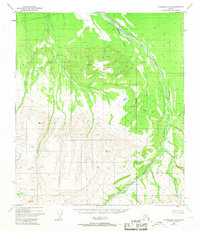
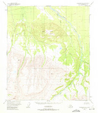
1949 Map of Fairbanks A-2
USGS Topo · Published 1967About this map
The Japan Hills anchor this interior Alaskan terrain, where the wide course of the Wood River meets the Fairbanks Meridian. Surveyed in the late 1940s, the map reveals a landscape defined by its waterways and remote navigation points, including a solitary Cabin and infrastructure such as a Radio Tower and Landing Strip near Gold King Creek. These markers suggest a period of early aviation and telegraphy reliance in the Tanana Valley backcountry.
Find a feature on this map
18 named features on this map. Tap any name to fly to it.
Don’t see what you’re looking for? This feature index may not catch every label — zoom into the map to look around manually.
Map Details
Editions of this 1949 Fairbanks A-2 Map
3 editions found
Historical Maps of Denali Through Time
460 maps found

1949 Fairbanks A-1
Denali Borough, AK

1949 Fairbanks A-2
Denali Borough, AK

1949 Fairbanks B-3
Denali Borough, AK

1949 Fairbanks B-4
Denali Borough, AK

1949 Fairbanks B-5
Denali Borough, AK

1949 Healy B-2
Denali Borough, AK

1949 Healy B-4
Denali Borough, AK

1949 Healy C-3
Denali Borough, AK

1949 Healy D-1
Denali Borough, AK

1950 Fairbanks A-3
Denali Borough, AK

1950 Fairbanks A-4
Denali Borough, AK

1950 Fairbanks A-5
Denali Borough, AK

1950 Fairbanks B-5
Denali Borough, AK

1950 Healy B-3
Denali Borough, AK

1950 Healy B-5
Denali Borough, AK

1950 Healy C-4
Denali Borough, AK

1950 Healy D-3
Denali Borough, AK

1950 Healy D-4
Denali Borough, AK

1951 Fairbanks A-5
Denali Borough, AK

1951 Fairbanks B-5
Denali Borough, AK

1951 Healy B-4
Denali Borough, AK

1951 Healy B-5
Denali Borough, AK

1951 Healy C-1
Denali Borough, AK

1951 Healy C-2
Denali Borough, AK

1951 Healy D-2
Denali Borough, AK

1951 Healy D-5
Denali Borough, AK

1951 Healy D-6
Denali Borough, AK

1951 Mount McKinley D-1
Denali Borough, AK

1952 Fairbanks A-1
Denali Borough, AK

1952 Fairbanks A-2
Denali Borough, AK

1952 Fairbanks A-3
Denali Borough, AK

1952 Fairbanks A-4
Denali Borough, AK

1952 Fairbanks A-6
Denali Borough, AK

1952 Fairbanks B-3
Denali Borough, AK

1952 Fairbanks B-4
Denali Borough, AK

1952 Healy B-2
Denali Borough, AK

1952 Healy B-3
Denali Borough, AK

1952 Healy C-3
Denali Borough, AK

1952 Healy C-4
Denali Borough, AK

1952 Healy C-5
Denali Borough, AK

1952 Healy D-1
Denali Borough, AK

1952 Healy D-2
Denali Borough, AK

1952 Healy D-3
Denali Borough, AK

1952 Healy D-4
Denali Borough, AK

1952 Healy D-5
Denali Borough, AK

1952 Kantishna River A-1
Denali Borough, AK

1952 Kantishna River A-2
Denali Borough, AK

1952 Mount McKinley A-5
Denali Borough, AK

1952 Mount McKinley B-1
Denali Borough, AK

1952 Mount McKinley B-2
Denali Borough, AK

1952 Mount McKinley C-1
Denali Borough, AK

1952 Mount McKinley C-2
Denali Borough, AK

1952 Mount McKinley C-3
Denali Borough, AK

1952 Mount McKinley D-3
Denali Borough, AK

1952 Mount McKinley
Denali Borough, AK

1953 Fairbanks B-6
Denali Borough, AK

1953 Healy B-5
Denali Borough, AK

1953 Healy C-5
Denali Borough, AK

1953 Kantishna River A-1
Denali Borough, AK

1953 Mount McKinley A-4
Denali Borough, AK

1953 Mount McKinley B-3
Denali Borough, AK

1953 Mount McKinley B-4
Denali Borough, AK

1953 Mount McKinley B-5
Denali Borough, AK

1953 Mount McKinley C-4
Denali Borough, AK

1953 Mount McKinley C-5
Denali Borough, AK

1953 Mount McKinley D-4
Denali Borough, AK

1954 Healy C-6
Denali Borough, AK

1954 Healy D-6
Denali Borough, AK

1954 Mount McKinley A-2
Denali Borough, AK

1954 Mount McKinley A-3
Denali Borough, AK

1954 Mount McKinley A-4
Denali Borough, AK

1954 Mount McKinley A-5
Denali Borough, AK

1954 Mount McKinley B-1
Denali Borough, AK

1954 Mount McKinley B-2
Denali Borough, AK

1954 Mount McKinley B-3
Denali Borough, AK

1954 Mount McKinley B-5
Denali Borough, AK

1954 Mount McKinley C-1
Denali Borough, AK

1954 Mount McKinley C-2
Denali Borough, AK

1954 Mount McKinley C-4
Denali Borough, AK

1954 Mount McKinley C-5
Denali Borough, AK

1954 Mount McKinley D-1
Denali Borough, AK

1954 Mount McKinley D-2
Denali Borough, AK

1954 Mount McKinley D-4
Denali Borough, AK

1956 Healy B-5
Denali Borough, AK

1958 Mt McKinley
Denali Borough, AK

1958 Talkeetna D-4
Denali Borough, AK

1958 Talkeetna D-5
Denali Borough, AK

1958 Talkeetna D-6
Denali Borough, AK

1969 Mount McKinley
Denali Borough, AK

1973 Fairbanks A-6
Denali Borough, AK

2013 Fairbanks A-3 NW
Denali Borough, AK

2013 Fairbanks A-4 NE
Denali Borough, AK

2013 Fairbanks A-4 NW
Denali Borough, AK

2013 Fairbanks A-4 SW
Denali Borough, AK

2013 Fairbanks A-5 NE
Denali Borough, AK

2013 Fairbanks A-5 NW
Denali Borough, AK

2013 Fairbanks A-5 SE
Denali Borough, AK

2013 Fairbanks A-5 SW
Denali Borough, AK

2013 Fairbanks A-6 NE
Denali Borough, AK

2013 Fairbanks A-6 NW
Denali Borough, AK

2013 Fairbanks A-6 SE
Denali Borough, AK

2013 Fairbanks A-6 SW
Denali Borough, AK

2013 Fairbanks B-3 SW
Denali Borough, AK

2013 Fairbanks B-4 SE
Denali Borough, AK

2013 Fairbanks B-4 SW
Denali Borough, AK

2013 Fairbanks B-5 SE
Denali Borough, AK

2013 Fairbanks B-5 SW
Denali Borough, AK

2013 Fairbanks B-6 SE
Denali Borough, AK

2013 Fairbanks B-6 SW
Denali Borough, AK

2014 Healy C-6 NW
Denali Borough, AK

2014 Healy C-6 SW
Denali Borough, AK

2014 Healy D-6 NW
Denali Borough, AK

2014 Healy D-6 SW
Denali Borough, AK

2014 Talkeetna D-3 NE
Denali Borough, AK

2014 Talkeetna D-3 NW
Denali Borough, AK

2014 Talkeetna D-4 NE
Denali Borough, AK

2014 Talkeetna D-4 NW
Denali Borough, AK

2014 Talkeetna D-4 SE
Denali Borough, AK

2014 Talkeetna D-4 SW
Denali Borough, AK

2015 Denali A-1 NW
Denali Borough, AK

2015 Denali A-2 NE
Denali Borough, AK

2015 Denali A-2 NW
Denali Borough, AK

2015 Denali A-2 SW
Denali Borough, AK

2015 Denali A-3 NE
Denali Borough, AK

2015 Denali A-3 NW
Denali Borough, AK

2015 Denali A-3 SE
Denali Borough, AK

2015 Denali A-3 SW
Denali Borough, AK

2015 Denali A-4 NE
Denali Borough, AK

2015 Denali A-4 NW
Denali Borough, AK

2015 Denali A-4 SE
Denali Borough, AK

2015 Denali A-4 SW
Denali Borough, AK

2015 Denali B-1 NE
Denali Borough, AK

2015 Denali B-1 NW
Denali Borough, AK

2015 Denali B-1 SW
Denali Borough, AK

2015 Denali B-2 NE
Denali Borough, AK

2015 Denali B-2 NW
Denali Borough, AK

2015 Denali B-2 SE
Denali Borough, AK

2015 Denali B-2 SW
Denali Borough, AK

2015 Denali B-3 NE
Denali Borough, AK

2015 Denali B-3 NW
Denali Borough, AK

2015 Denali B-3 SE
Denali Borough, AK

2015 Denali B-3 SW
Denali Borough, AK

2015 Denali C-1 NE
Denali Borough, AK

2015 Denali C-1 NW
Denali Borough, AK

2015 Denali C-1 SE
Denali Borough, AK

2015 Denali C-1 SW
Denali Borough, AK

2015 Denali C-2 NE
Denali Borough, AK

2015 Denali C-2 NW
Denali Borough, AK

2015 Denali C-2 SE
Denali Borough, AK

2015 Denali C-2 SW
Denali Borough, AK

2015 Denali C-3 NE
Denali Borough, AK

2015 Denali C-3 NW
Denali Borough, AK

2015 Denali C-3 SE
Denali Borough, AK

2015 Denali C-3 SW
Denali Borough, AK

2015 Denali C-4 NE
Denali Borough, AK

2015 Denali C-4 SE
Denali Borough, AK

2015 Denali D-1 NE
Denali Borough, AK

2015 Denali D-1 NW
Denali Borough, AK

2015 Denali D-1 SE
Denali Borough, AK

2015 Denali D-1 SW
Denali Borough, AK

2015 Denali D-2 NE
Denali Borough, AK

2015 Denali D-2 SE
Denali Borough, AK

2015 Denali D-2 SW
Denali Borough, AK

2015 Denali D-3 NW
Denali Borough, AK

2015 Denali D-3 SE
Denali Borough, AK

2015 Denali D-3 SW
Denali Borough, AK

2015 Denali D-4 NE
Denali Borough, AK

2015 Denali D-4 SE
Denali Borough, AK

2016 Denali B-1 SE
Denali Borough, AK

2016 Denali D-2 NW
Denali Borough, AK

2016 Denali D-3 NE
Denali Borough, AK

2016 Fairbanks A-1 NE
Denali Borough, AK

2016 Fairbanks A-1 NW
Denali Borough, AK

2016 Fairbanks A-1 SE
Denali Borough, AK

2016 Fairbanks A-1 SW
Denali Borough, AK

2016 Fairbanks A-2 NE
Denali Borough, AK

2016 Fairbanks A-2 NW
Denali Borough, AK

2016 Fairbanks A-2 SE
Denali Borough, AK

2016 Fairbanks A-2 SW
Denali Borough, AK

2016 Fairbanks A-3 NE
Denali Borough, AK

2016 Fairbanks A-3 SE
Denali Borough, AK

2016 Fairbanks A-3 SW
Denali Borough, AK

2016 Fairbanks B-3 SE
Denali Borough, AK

2016 Healy A-3 NE
Denali Borough, AK

2016 Healy A-3 NW
Denali Borough, AK

2016 Healy A-4 NE
Denali Borough, AK

2016 Healy B-2 NW
Denali Borough, AK

2016 Healy B-2 SW
Denali Borough, AK

2016 Healy B-3 NE
Denali Borough, AK

2016 Healy B-3 NW
Denali Borough, AK

2016 Healy B-3 SE
Denali Borough, AK

2016 Healy B-3 SW
Denali Borough, AK

2016 Healy B-4 NE
Denali Borough, AK

2016 Healy B-4 NW
Denali Borough, AK

2016 Healy B-4 SE
Denali Borough, AK

2016 Healy B-5 NE
Denali Borough, AK

2016 Healy B-5 NW
Denali Borough, AK

2016 Healy B-6 NE
Denali Borough, AK

2016 Healy B-6 NW
Denali Borough, AK

2016 Healy C-1 NE
Denali Borough, AK

2016 Healy C-1 NW
Denali Borough, AK

2016 Healy C-2 NE
Denali Borough, AK

2016 Healy C-2 NW
Denali Borough, AK

2016 Healy C-2 SE
Denali Borough, AK

2016 Healy C-2 SW
Denali Borough, AK

2016 Healy C-3 NE
Denali Borough, AK

2016 Healy C-3 NW
Denali Borough, AK

2016 Healy C-3 SE
Denali Borough, AK

2016 Healy C-3 SW
Denali Borough, AK

2016 Healy C-4 NE
Denali Borough, AK

2016 Healy C-4 NW
Denali Borough, AK

2016 Healy C-4 SE
Denali Borough, AK

2016 Healy C-4 SW
Denali Borough, AK

2016 Healy C-5 NE
Denali Borough, AK

2016 Healy C-5 NW
Denali Borough, AK

2016 Healy C-5 SE
Denali Borough, AK

2016 Healy C-5 SW
Denali Borough, AK

2016 Healy C-6 NE
Denali Borough, AK

2016 Healy C-6 SE
Denali Borough, AK

2016 Healy D-1 NE
Denali Borough, AK

2016 Healy D-1 NW
Denali Borough, AK

2016 Healy D-1 SE
Denali Borough, AK

2016 Healy D-1 SW
Denali Borough, AK

2016 Healy D-2 NE
Denali Borough, AK

2016 Healy D-2 NW
Denali Borough, AK

2016 Healy D-2 SE
Denali Borough, AK

2016 Healy D-2 SW
Denali Borough, AK

2016 Healy D-3 NE
Denali Borough, AK

2016 Healy D-3 NW
Denali Borough, AK

2016 Healy D-3 SE
Denali Borough, AK

2016 Healy D-3 SW
Denali Borough, AK

2016 Healy D-4 NE
Denali Borough, AK

2016 Healy D-4 NW
Denali Borough, AK

2016 Healy D-4 SE
Denali Borough, AK

2016 Healy D-4 SW
Denali Borough, AK

2016 Healy D-5 NE
Denali Borough, AK

2016 Healy D-5 NW
Denali Borough, AK

2016 Healy D-5 SE
Denali Borough, AK

2016 Healy D-5 SW
Denali Borough, AK

2016 Healy D-6 NE
Denali Borough, AK

2016 Healy D-6 SE
Denali Borough, AK

2017 Denali A-5 NE
Denali Borough, AK

2017 Denali A-5 NW
Denali Borough, AK

2017 Denali A-5 SE
Denali Borough, AK

2017 Denali A-5 SW
Denali Borough, AK

2017 Denali A-6 NE
Denali Borough, AK

2017 Denali A-6 NW
Denali Borough, AK

2017 Denali A-6 SE
Denali Borough, AK

2017 Denali A-6 SW
Denali Borough, AK

2017 Denali B-4 NE
Denali Borough, AK

2017 Denali B-4 NW
Denali Borough, AK

2017 Denali B-4 SE
Denali Borough, AK

2017 Denali B-4 SW
Denali Borough, AK

2017 Denali B-5 NE
Denali Borough, AK

2017 Denali B-5 NW
Denali Borough, AK

2017 Denali B-5 SE
Denali Borough, AK

2017 Denali B-5 SW
Denali Borough, AK

2017 Denali B-6 NE
Denali Borough, AK

2017 Denali B-6 NW
Denali Borough, AK

2017 Denali B-6 SE
Denali Borough, AK

2017 Denali B-6 SW
Denali Borough, AK

2017 Denali C-4 NW
Denali Borough, AK

2017 Denali C-4 SW
Denali Borough, AK

2017 Denali C-5 NE
Denali Borough, AK

2017 Denali C-5 NW
Denali Borough, AK

2017 Denali C-5 SE
Denali Borough, AK

2017 Denali C-5 SW
Denali Borough, AK

2017 Denali C-6 NE
Denali Borough, AK

2017 Denali C-6 NW
Denali Borough, AK

2017 Denali C-6 SE
Denali Borough, AK

2017 Denali C-6 SW
Denali Borough, AK

2017 Denali D-4 NW
Denali Borough, AK

2017 Denali D-4 SW
Denali Borough, AK

2017 Denali D-5 NE
Denali Borough, AK

2017 Denali D-5 NW
Denali Borough, AK

2017 Denali D-5 SE
Denali Borough, AK

2017 Denali D-5 SW
Denali Borough, AK

2017 Denali D-6 NE
Denali Borough, AK

2017 Denali D-6 NW
Denali Borough, AK

2017 Denali D-6 SE
Denali Borough, AK

2017 Denali D-6 SW
Denali Borough, AK

2017 Fairbanks A-4 SE
Denali Borough, AK

2017 Kantishna River A-1 NE
Denali Borough, AK

2017 Kantishna River A-1 NW
Denali Borough, AK

2017 Kantishna River A-1 SE
Denali Borough, AK

2017 Kantishna River A-1 SW
Denali Borough, AK

2017 Kantishna River A-2 NE
Denali Borough, AK

2017 Kantishna River A-2 NW
Denali Borough, AK

2017 Kantishna River A-2 SE
Denali Borough, AK

2017 Kantishna River A-2 SW
Denali Borough, AK

2017 Kantishna River A-3 SE
Denali Borough, AK

2017 Kantishna River A-4 SE
Denali Borough, AK

2017 Kantishna River B-1 SE
Denali Borough, AK

2017 Kantishna River B-1 SW
Denali Borough, AK

2017 Kantishna River B-2 SE
Denali Borough, AK

2017 Talkeetna D-5 NE
Denali Borough, AK

2017 Talkeetna D-5 NW
Denali Borough, AK

2017 Talkeetna D-5 SE
Denali Borough, AK

2017 Talkeetna D-5 SW
Denali Borough, AK

2017 Talkeetna D-6 NE
Denali Borough, AK

2017 Talkeetna D-6 NW
Denali Borough, AK

2017 Talkeetna D-6 SE
Denali Borough, AK

2017 Talkeetna D-6 SW
Denali Borough, AK

2019 Denali B-1 NE
Denali Borough, AK

2019 Denali B-1 NW
Denali Borough, AK

2019 Denali B-2 NE
Denali Borough, AK

2019 Denali B-2 NW
Denali Borough, AK

2019 Denali C-1 SE
Denali Borough, AK

2019 Denali C-2 SE
Denali Borough, AK

2019 Denali C-2 SW
Denali Borough, AK

2019 Healy B-4 NW
Denali Borough, AK

2019 Healy B-5 NE
Denali Borough, AK

2019 Healy C-4 NW
Denali Borough, AK

2019 Healy C-5 NE
Denali Borough, AK

2019 Healy C-5 NW
Denali Borough, AK

2019 Healy C-6 NE
Denali Borough, AK

2019 Healy C-6 SE
Denali Borough, AK

2019 Healy C-6 SW
Denali Borough, AK

2019 Healy D-4 SW
Denali Borough, AK

2019 Healy D-5 SW
Denali Borough, AK

2023 Denali A-1 NW
Denali Borough, AK

2023 Denali A-2 NE
Denali Borough, AK

2023 Denali A-2 NW
Denali Borough, AK

2023 Denali A-2 SW
Denali Borough, AK

2023 Denali A-3 NE
Denali Borough, AK

2023 Denali A-3 NW
Denali Borough, AK

2023 Denali A-3 SE
Denali Borough, AK

2023 Denali A-3 SW
Denali Borough, AK

2023 Denali A-4 NE
Denali Borough, AK

2023 Denali A-4 NW
Denali Borough, AK

2023 Denali A-4 SE
Denali Borough, AK

2023 Denali A-4 SW
Denali Borough, AK

2023 Denali A-5 NE
Denali Borough, AK

2023 Denali A-5 NW
Denali Borough, AK

2023 Denali A-5 SE
Denali Borough, AK

2023 Denali A-5 SW
Denali Borough, AK

2023 Denali A-6 NE
Denali Borough, AK

2023 Denali A-6 NW
Denali Borough, AK

2023 Denali A-6 SE
Denali Borough, AK

2023 Denali A-6 SW
Denali Borough, AK

2023 Denali B-1 NE
Denali Borough, AK

2023 Denali B-1 NW
Denali Borough, AK

2023 Denali B-1 SE
Denali Borough, AK

2023 Denali B-1 SW
Denali Borough, AK

2023 Denali B-2 NE
Denali Borough, AK

2023 Denali B-2 NW
Denali Borough, AK

2023 Denali B-2 SE
Denali Borough, AK

2023 Denali B-2 SW
Denali Borough, AK

2023 Denali B-3 NE
Denali Borough, AK

2023 Denali B-3 NW
Denali Borough, AK

2023 Denali B-3 SE
Denali Borough, AK

2023 Denali B-3 SW
Denali Borough, AK

2023 Denali B-4 NE
Denali Borough, AK

2023 Denali B-4 NW
Denali Borough, AK

2023 Denali B-4 SE
Denali Borough, AK

2023 Denali B-4 SW
Denali Borough, AK

2023 Denali B-5 NE
Denali Borough, AK

2023 Denali B-5 NW
Denali Borough, AK

2023 Denali B-5 SE
Denali Borough, AK

2023 Denali B-5 SW
Denali Borough, AK

2023 Denali B-6 NE
Denali Borough, AK

2023 Denali B-6 NW
Denali Borough, AK

2023 Denali B-6 SE
Denali Borough, AK

2023 Denali B-6 SW
Denali Borough, AK

2023 Denali C-1 NE
Denali Borough, AK

2023 Denali C-1 NW
Denali Borough, AK

2023 Denali C-1 SE
Denali Borough, AK

2023 Denali C-1 SW
Denali Borough, AK

2023 Denali C-2 NE
Denali Borough, AK

2023 Denali C-2 NW
Denali Borough, AK

2023 Denali C-2 SE
Denali Borough, AK

2023 Denali C-2 SW
Denali Borough, AK

2023 Denali C-3 NE
Denali Borough, AK

2023 Denali C-3 NW
Denali Borough, AK

2023 Denali C-3 SE
Denali Borough, AK

2023 Denali C-3 SW
Denali Borough, AK

2023 Denali C-4 NE
Denali Borough, AK

2023 Denali C-4 NW
Denali Borough, AK

2023 Denali C-4 SE
Denali Borough, AK

2023 Denali C-4 SW
Denali Borough, AK

2023 Denali C-5 NE
Denali Borough, AK

2023 Denali C-5 NW
Denali Borough, AK

2023 Denali C-5 SE
Denali Borough, AK

2023 Denali C-5 SW
Denali Borough, AK

2023 Denali C-6 NE
Denali Borough, AK

2023 Denali C-6 NW
Denali Borough, AK

2023 Denali C-6 SE
Denali Borough, AK

2023 Denali C-6 SW
Denali Borough, AK

2023 Denali D-1 NE
Denali Borough, AK

2023 Denali D-1 NW
Denali Borough, AK

2023 Denali D-1 SE
Denali Borough, AK

2023 Denali D-1 SW
Denali Borough, AK

2023 Denali D-2 NE
Denali Borough, AK

2023 Denali D-2 NW
Denali Borough, AK

2023 Denali D-2 SE
Denali Borough, AK

2023 Denali D-2 SW
Denali Borough, AK

2023 Denali D-3 NE
Denali Borough, AK

2023 Denali D-3 NW
Denali Borough, AK

2023 Denali D-3 SE
Denali Borough, AK

2023 Denali D-3 SW
Denali Borough, AK

2023 Denali D-4 NE
Denali Borough, AK

2023 Denali D-4 NW
Denali Borough, AK

2023 Denali D-4 SE
Denali Borough, AK

2023 Denali D-4 SW
Denali Borough, AK

2023 Denali D-5 NE
Denali Borough, AK

2023 Denali D-5 NW
Denali Borough, AK

2023 Denali D-5 SE
Denali Borough, AK

2023 Denali D-5 SW
Denali Borough, AK

2023 Denali D-6 NE
Denali Borough, AK

2023 Denali D-6 NW
Denali Borough, AK

2023 Denali D-6 SE
Denali Borough, AK

2023 Denali D-6 SW
Denali Borough, AK

2023 Talkeetna D-3 NE
Denali Borough, AK

2023 Talkeetna D-3 NW
Denali Borough, AK

2023 Talkeetna D-4 NE
Denali Borough, AK

2023 Talkeetna D-4 NW
Denali Borough, AK

2023 Talkeetna D-4 SE
Denali Borough, AK

2023 Talkeetna D-4 SW
Denali Borough, AK

2024 Fairbanks A-6 NW
Denali Borough, AK

2024 Fairbanks A-6 SE
Denali Borough, AK

2024 Fairbanks A-6 SW
Denali Borough, AK

2024 Fairbanks B-6 SW
Denali Borough, AK

2024 Healy A-3 NE
Denali Borough, AK

2024 Healy A-3 NW
Denali Borough, AK

2024 Healy A-4 NE
Denali Borough, AK

2024 Healy B-5 NW
Denali Borough, AK

2024 Healy B-6 NE
Denali Borough, AK

2024 Healy B-6 NW
Denali Borough, AK

2024 Healy C-2 SE
Denali Borough, AK

2024 Healy C-6 NE
Denali Borough, AK

2024 Healy C-6 NW
Denali Borough, AK

2024 Healy C-6 SE
Denali Borough, AK

2024 Healy C-6 SW
Denali Borough, AK

2024 Healy D-6 NE
Denali Borough, AK

2024 Healy D-6 NW
Denali Borough, AK

2024 Healy D-6 SE
Denali Borough, AK

2024 Healy D-6 SW
Denali Borough, AK

2024 Kantishna River A-1 NE
Denali Borough, AK

2024 Kantishna River A-1 NW
Denali Borough, AK

2024 Kantishna River A-1 SE
Denali Borough, AK

2024 Kantishna River A-1 SW
Denali Borough, AK

2024 Kantishna River A-2 NE
Denali Borough, AK

2024 Kantishna River A-2 NW
Denali Borough, AK

2024 Kantishna River A-2 SE
Denali Borough, AK

2024 Kantishna River A-2 SW
Denali Borough, AK

2024 Kantishna River A-3 SE
Denali Borough, AK

2024 Kantishna River A-4 SE
Denali Borough, AK

2024 Kantishna River B-1 SE
Denali Borough, AK

2024 Kantishna River B-1 SW
Denali Borough, AK

2024 Kantishna River B-2 SE
Denali Borough, AK

2024 Talkeetna D-5 NE
Denali Borough, AK

2024 Talkeetna D-5 NW
Denali Borough, AK

2024 Talkeetna D-5 SE
Denali Borough, AK

2024 Talkeetna D-5 SW
Denali Borough, AK

2024 Talkeetna D-6 NE
Denali Borough, AK

2024 Talkeetna D-6 NW
Denali Borough, AK

2024 Talkeetna D-6 SE
Denali Borough, AK

2024 Talkeetna D-6 SW
Denali Borough, AK

2025 Denali A-2 SW
Denali Borough, AK

2025 Denali A-3 SE
Denali Borough, AK