
1949 Map of Fairbanks A-1
USGS Topo · Published 1968About this map
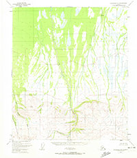
Dry Creek dominates the interior drainage of this Alaskan landscape as it was mapped in 1949, flowing northward from the high elevations of the south. The terrain is defined by dramatic shifts in topography, where the braided channels of the north give way to the prominent peaks of Snow Mountain and the high point at VABM Slide 3609. This photogrammetric survey, based on aerial photography from just after the war, documents an area largely devoid of roads or permanent settlements at the time. Further south, the landscape is deeply etched by Slide Creek and Threemile Creek, which cut through the southern ridges near a feature simply labeled as the Gulch. This 1949 survey provides a baseline of the interior wilderness before later development or significant human infrastructure altered the character of these remote watersheds.
Find a feature on this map
7 named features on this map. Tap any name to fly to it.
Don’t see what you’re looking for? This feature index may not catch every label — zoom into the map to look around manually.
Map Details
Editions of this 1949 Fairbanks A-1 Map
2 editions found
Other maps of this area

1949 · Big Delta B-6
USGS Topo · 1:63,360

1949 · Big Delta A-6
USGS Topo · 1:63,360

1949 · Fairbanks A-2
USGS Topo · 1:63,360

1949 · Healy D-1
USGS Topo · 1:63,360

1950 · Fairbanks
USGS Topo · 1:250,000

1950 · Mount Hayes
USGS Topo · 1:250,000

1950 · Big Delta
USGS Topo · 1:250,000

1950 · Mount Hayes D-6
USGS Topo · 1:63,360

1950 · Fairbanks B-2
USGS Topo · 1:63,360

1950 · Fairbanks B-1
USGS Topo · 1:63,360