Loading...
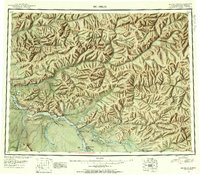
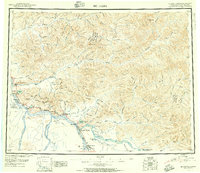
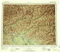
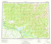
Loading map...1950 Map of Big Delta
USGS Topo · Published 1956About this map
The Tanana River corridor serves as the primary artery of development on this mid-century reconnaissance sheet, where the Richardson Highway connects a series of remote outposts and lodges. The strategic importance of the region is anchored by Fort Greely and the extensive Ladd Air Force Base Bombing and Gunnery Range, reflecting the era's military focus in Alaska. Near the confluence of the Delta River and the Tanana, the settlement of Big Delta and the nearby Buffalo Center stand as vital hubs for travelers and residents alike.
Find a feature on this map
132 named features on this map. Tap any name to fly to it.
Don’t see what you’re looking for? This feature index may not catch every label — zoom into the map to look around manually.
Map Details
Date Portrayed1950
Date Published1956
PublisherU.S. Geological Survey
Map TypeTopographic
Scale1:250,000
Physical Dimensions25.3 x 22.2 inches
Editions of this 1950 Big Delta Map
2 editions found
Historical Maps of Delta Junction Through Time
3 maps found
Featured Locations
Source Details
SourceU.S. Geological Survey
CopyrightPublic Domain