Old Maps of Delta Junction, Alaska
Explore 9 old maps of Delta Junction, spanning from 1950 to today. These high-resolution historic maps reveal how streets, neighborhoods, landmarks, and natural features evolved over time — perfect for genealogy, metal detecting, research, and local history exploration.
What you can do with these maps:
- See how Delta Junction changed over time: Compare historical maps to modern-day views to trace roads, homesites, rail lines & more.
- View detailed metadata: Each map includes creators, publishers, year, scale, and archive source.
- Overlay maps with satellite & LiDAR: Visualize the past alongside modern tools to explore terrain & human change.
- Trusted historical sources: Maps sourced from the USGS, Library of Congress, and other archives.
- Access maps your way: View online, download high-res files, or order prints for personal or research use.
Start exploring old maps of Delta Junction to uncover forgotten places, hidden landmarks, and the deep history beneath your feet.
Delta Junction, AK maps
(9)- 1950 Map of Big Delta, 1956 Print
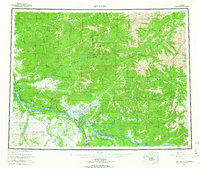
 1950 Big Delta1956 Print · USGSAlaska's interior corridors reveal a landscape of military outposts and river-valley lodges in the mid-twentieth century. Trace historic routes along the Richardson Highway to find Big Delta, Fort Greely, and Shaw Creek Lodge.2 unique versions available
 - 1950 Map of Big Delta A-4, 1963 Print
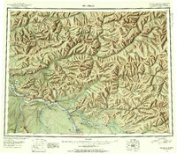
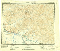
 1950 Big Delta A-41963 Print · USGSIn the mid-century Alaskan interior, this survey shows the strategic growth of Delta Junction at the intersection of two major highways. Local historians can trace the early footprint of Fort Greely and locate sites like the abandoned Big Delta and Jollys Cabins.4 unique versions available
 - 1951 Map of Big Delta
 1951 Big Delta1951 Print · USGSThe interior of Alaska is captured at a critical junction during the post-war era as the highway system expanded. Genealogists and historians can trace early roadside landmarks like Aurora Lodge, Tenderfoot, and the original settlement layout of Big Delta.4 unique versions available
 - 1952 Map of Big Delta A-4
 1952 Big Delta A-41952 Print · USGSSoutheast Fairbanks during the early fifties shows a landscape in transition as highway intersections began to supersede river outposts. Genealogists and historians can trace the foundations of Delta Junction and locate early sites like Bert & Marys Roadhouse and Big Delta (Aband).2 unique versions available
 - 1958 Map of Big Delta, 1966 Print
 1958 Big Delta1966 Print · USGSInterior Alaska at the height of the mid-century expansion reveals a landscape of strategic military outposts and remote river settlements. Trace the junction of the Tanana River and the Richardson Highway near Big Delta and the Healy Lake Indian Village.6 unique versions available
 - 1959 Map of Big Delta A-4, 1960 Print
 1959 Big Delta A-41960 Print · USGSInterior Alaska at the junction of the Tanana and Delta Rivers is captured here during the mid-twentieth century. Researchers can locate landmarks like Bert & Marys Roadhouse and Buffalo Center or trace the early footprint of Fort Greeley.
 - 1962 Map of Big Delta A-4, 1963 Print
 1962 Big Delta A-41963 Print · USGSSoutheast Fairbanks in the early sixties reveals a landscape shaped by glacial rivers and the intersection of the Richardson and Alaska Highways. Researchers can locate the footprint of Fort Greely or trace the early paths of the Winter Trail and Jollys Cabins.
 - 2016 Map of Big Delta A-4 SE, 2016 Print
 2016 Big Delta A-4 SE2016 Print · USGSCovers Delta Junction, including Unorganized Borough, United States, and other nearby areas
 - 2024 Map of Big Delta A-4 SE, 2024 Print
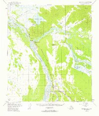
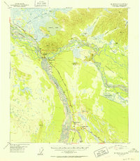
 2024 Big Delta A-4 SE2024 Print · USGSThe interior of Alaska at the junction of the Tanana and Delta rivers shows a landscape shaped by military history and the energy industry. Researchers can trace the Alaska Pipeline as it passes Fort Greely and the quiet grounds of Rest Haven Cem.
End of results
Showing maps 1-9 of 9
Frequently asked questions
- What are the different types of historical maps available for Delta Junction?
- What is the oldest map of Delta Junction?
- Where can I purchase historical maps of Delta Junction for my home or office?
- Where can I download high-res historical maps of Delta Junction?
- Are there historical topographic maps available for Delta Junction?
- Is there historical aerial imagery available for Delta Junction?
- Where are historical maps of Delta Junction sourced from?