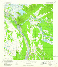
1959 Map of Big Delta A-4
USGS Topo · Published 1960About this map
Fort Greeley anchors the southern portion of this mid-century survey, situated at the strategic confluence where the Delta River meets the mighty Tanana River. This region represents a vital transportation corridor in Alaska’s interior, marked by the intersection of the Richardson Highway and the Alaska Highway. The map captures a period of transition, noting the location of Big Delta (Aband) alongside active service points like Buffalo Center and Bert & Marys Roadhouse. To the north, the landscape opens into the expansive Shaw Creek Flats and the Goodpaster Flats, characterized by numerous water bodies such as Quartz Lake and Clearwater Lake. Scattered landmarks like Jollys Cabins and several unnamed cabins along the Goodpaster River and Winter Trail suggest the area's ongoing importance for both military operations and localized interior travel.
Find a feature on this map
29 named features on this map. Tap any name to fly to it.
Don’t see what you’re looking for? This feature index may not catch every label — zoom into the map to look around manually.
Map Details
Editions of this 1959 Big Delta A-4 Map
This is the sole edition of this map. No revisions or reprints were ever made.
Other maps of this area

1949 · Big Delta B-5
USGS Topo · 1:63,360

1950 · Mount Hayes
USGS Topo · 1:250,000

1950 · Big Delta
USGS Topo · 1:250,000

1950 · Big Delta A-5
USGS Topo · 1:63,360

1950 · Mount Hayes D-4
USGS Topo · 1:63,360

1950 · Big Delta A-4
USGS Topo · 1:63,360

1950 · Mount Hayes D-5
USGS Topo · 1:63,360

1950 · Big Delta B-4
USGS Topo · 1:63,360

1951 · Big Delta
USGS Topo · 1:250,000

1951 · Mount Hayes
USGS Topo · 1:250,000