
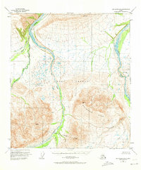
1950 Map of Mount Hayes D-6
USGS Topo · Published 1964About this map
The Fort Greely Military Reservation dominates this 1950s interior landscape, where the Fort Greely Military Reservation Boundary delineates a massive tract of land set aside for defense. The terrain is defined by the braided channels of the Little Delta River and the Delta River, which carve through the valley floors between steep rises. High above the water, the prominent Molybdenum Ridge provides a significant landmark for the region, overlooking a network of tributary drainages including the West Fork and East Fork. Numerous smaller streams like Jarvis Creek, Buchanan Creek, and Whistler Creek feed into the larger river systems. This survey, based on 1949 aerial photography, documents the area before significant infrastructure development, showing a land primarily shaped by glacial waters and military designation.
Find a feature on this map
15 named features on this map. Tap any name to fly to it.
Don’t see what you’re looking for? This feature index may not catch every label — zoom into the map to look around manually.
Map Details
Editions of this 1950 Mount Hayes D-6 Map
2 editions found
Other maps of this area

1949 · Big Delta A-6
USGS Topo · 1:63,360

1949 · Fairbanks A-1
USGS Topo · 1:63,360

1949 · Healy D-1
USGS Topo · 1:63,360

1950 · Fairbanks
USGS Topo · 1:250,000

1950 · Mount Hayes
USGS Topo · 1:250,000

1950 · Big Delta
USGS Topo · 1:250,000

1950 · Big Delta A-5
USGS Topo · 1:63,360

1950 · Mount Hayes D-5
USGS Topo · 1:63,360

1951 · Healy
USGS Topo · 1:250,000

1951 · Big Delta
USGS Topo · 1:250,000