
1951 Map of Fairbanks B-2
USGS Topo · Published 1951About this map
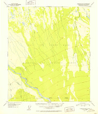
The Wood River flows through a landscape defined by mid-century military operations in the Alaskan interior. This 1951 record shows the expansive Ladd Air Force Base, which at the time utilized a massive Bombing and Gunnery Range stretching across the tundra. The terrain is marked by numerous watercourses, including the braided channels of Bonnifield and the steady paths of Gold King Creek and Willow Creek. The southern edge of the survey is delineated by the Military Reservation Boundary (Approximate), indicating the scale of federal land use in the Tanana Valley during the early Cold War era. This map provides a clear view of the intersection between Alaska's natural drainage systems and its strategic importance as a defense hub.
Find a feature on this map
10 named features on this map. Tap any name to fly to it.
Don’t see what you’re looking for? This feature index may not catch every label — zoom into the map to look around manually.
Map Details
Editions of this 1951 Fairbanks B-2 Map
2 editions found
Historical Maps of Fairbanks North Star Through Time
340 maps found

1949 Big Delta B-5
Fairbanks North Star Borough, AK

1949 Big Delta B-6
Fairbanks North Star Borough, AK

1949 Big Delta C-6
Fairbanks North Star Borough, AK

1949 Fairbanks C-1
Fairbanks North Star Borough, AK

1949 Fairbanks C-2
Fairbanks North Star Borough, AK

1949 Fairbanks D-1
Fairbanks North Star Borough, AK

1949 Fairbanks D-2
Fairbanks North Star Borough, AK

1949 Fairbanks D-3
Fairbanks North Star Borough, AK

1950 Big Delta D-6
Fairbanks North Star Borough, AK

1950 Fairbanks B-1
Fairbanks North Star Borough, AK

1950 Fairbanks B-2
Fairbanks North Star Borough, AK

1950 Fairbanks C-1
Fairbanks North Star Borough, AK

1950 Fairbanks C-3
Fairbanks North Star Borough, AK

1950 Fairbanks D-3
Fairbanks North Star Borough, AK

1951 Circle A-5
Fairbanks North Star Borough, AK

1951 Fairbanks B-1
Fairbanks North Star Borough, AK
1951 Fairbanks B-2
Fairbanks North Star Borough, AK

1952 Big Delta B-5
Fairbanks North Star Borough, AK

1952 Big Delta B-6
Fairbanks North Star Borough, AK

1952 Big Delta C-6
Fairbanks North Star Borough, AK

1952 Big Delta D-6
Fairbanks North Star Borough, AK

1952 Circle A-4
Fairbanks North Star Borough, AK

1952 Circle A-5
Fairbanks North Star Borough, AK

1952 Fairbanks C-1
Fairbanks North Star Borough, AK

1952 Fairbanks C-2
Fairbanks North Star Borough, AK

1952 Fairbanks C-3
Fairbanks North Star Borough, AK

1952 Fairbanks D-1
Fairbanks North Star Borough, AK

1952 Fairbanks D-2
Fairbanks North Star Borough, AK

1952 Fairbanks D-3
Fairbanks North Star Borough, AK

1952 Livengood A-1
Fairbanks North Star Borough, AK

1952 Livengood A-2
Fairbanks North Star Borough, AK

1953 Livengood A-3
Fairbanks North Star Borough, AK

1954 Circle A-5
Fairbanks North Star Borough, AK

1954 Circle A-6
Fairbanks North Star Borough, AK

1954 Circle B-5
Fairbanks North Star Borough, AK

1954 Fairbanks D-2
Fairbanks North Star Borough, AK

1954 Livengood A-1
Fairbanks North Star Borough, AK

1954 Livengood A-2
Fairbanks North Star Borough, AK

1955 Fairbanks D-2
Fairbanks North Star Borough, AK

1958 Big Delta C-2
Fairbanks North Star Borough, AK

1958 Big Delta C-3
Fairbanks North Star Borough, AK

1958 Big Delta C-4
Fairbanks North Star Borough, AK

1958 Big Delta C-5
Fairbanks North Star Borough, AK

1958 Big Delta D-1
Fairbanks North Star Borough, AK

1958 Big Delta D-2
Fairbanks North Star Borough, AK

1958 Big Delta D-3
Fairbanks North Star Borough, AK

1958 Big Delta D-4
Fairbanks North Star Borough, AK

1958 Big Delta D-5
Fairbanks North Star Borough, AK

1965 Fairbanks D-2
Fairbanks North Star Borough, AK

1966 Fairbanks D-1 SW
Fairbanks North Star Borough, AK

1966 Fairbanks D-2 NE
Fairbanks North Star Borough, AK

1966 Fairbanks D-2 NW
Fairbanks North Star Borough, AK

1966 Fairbanks D-2 SE
Fairbanks North Star Borough, AK

1966 Fairbanks D-2 SW
Fairbanks North Star Borough, AK

1973 Big Delta D-3
Fairbanks North Star Borough, AK

1992 Big Delta B-6 NW
Fairbanks North Star Borough, AK

1992 Big Delta C-6 NW
Fairbanks North Star Borough, AK

1992 Big Delta C-6 SW
Fairbanks North Star Borough, AK

1992 Big Delta D-6 NW
Fairbanks North Star Borough, AK

1992 Big Delta D-6 SW
Fairbanks North Star Borough, AK

1992 Fairbanks C-1 NE
Fairbanks North Star Borough, AK

1992 Fairbanks C-1 NW
Fairbanks North Star Borough, AK

1992 Fairbanks C-1 SE
Fairbanks North Star Borough, AK

1992 Fairbanks D-1 NE
Fairbanks North Star Borough, AK

1992 Fairbanks D-1 NW
Fairbanks North Star Borough, AK

1992 Fairbanks D-1 SE
Fairbanks North Star Borough, AK

1992 Fairbanks D-1 SW
Fairbanks North Star Borough, AK

1992 Fairbanks D-2 NE
Fairbanks North Star Borough, AK

1992 Fairbanks D-2 NW
Fairbanks North Star Borough, AK

1992 Fairbanks D-2 SE
Fairbanks North Star Borough, AK

1992 Fairbanks D-2 SW
Fairbanks North Star Borough, AK

1992 Fairbanks D-3 NE
Fairbanks North Star Borough, AK

1992 Fairbanks D-3 SE
Fairbanks North Star Borough, AK

1992 Fairbanks D-3 SW
Fairbanks North Star Borough, AK

1992 Livengood A-1 SE
Fairbanks North Star Borough, AK

1992 Livengood A-1 SW
Fairbanks North Star Borough, AK

1992 Livengood A-2 SE
Fairbanks North Star Borough, AK

2013 Big Delta B-6 NW
Fairbanks North Star Borough, AK

2013 Big Delta B-6 SW
Fairbanks North Star Borough, AK

2013 Fairbanks B-1 NE
Fairbanks North Star Borough, AK

2013 Fairbanks B-1 NW
Fairbanks North Star Borough, AK

2013 Fairbanks B-1 SE
Fairbanks North Star Borough, AK

2013 Fairbanks B-1 SW
Fairbanks North Star Borough, AK

2013 Fairbanks B-2 NE
Fairbanks North Star Borough, AK

2013 Fairbanks B-2 NW
Fairbanks North Star Borough, AK

2013 Fairbanks B-2 SE
Fairbanks North Star Borough, AK

2013 Fairbanks B-2 SW
Fairbanks North Star Borough, AK

2013 Fairbanks B-3 NE
Fairbanks North Star Borough, AK

2013 Fairbanks C-2 NE
Fairbanks North Star Borough, AK

2013 Fairbanks C-2 NW
Fairbanks North Star Borough, AK

2013 Fairbanks C-2 SE
Fairbanks North Star Borough, AK

2013 Fairbanks C-2 SW
Fairbanks North Star Borough, AK

2013 Fairbanks C-3 NE
Fairbanks North Star Borough, AK

2013 Fairbanks C-3 NW
Fairbanks North Star Borough, AK

2013 Fairbanks C-3 SE
Fairbanks North Star Borough, AK

2013 Fairbanks C-3 SW
Fairbanks North Star Borough, AK

2013 Fairbanks D-2 NW
Fairbanks North Star Borough, AK

2013 Fairbanks D-2 SW
Fairbanks North Star Borough, AK

2013 Fairbanks D-3 NE
Fairbanks North Star Borough, AK

2013 Fairbanks D-3 NW
Fairbanks North Star Borough, AK

2013 Fairbanks D-3 SE
Fairbanks North Star Borough, AK

2013 Fairbanks D-3 SW
Fairbanks North Star Borough, AK

2016 Big Delta B-5 NE
Fairbanks North Star Borough, AK

2016 Big Delta B-5 NW
Fairbanks North Star Borough, AK

2016 Big Delta B-5 SW
Fairbanks North Star Borough, AK

2016 Big Delta B-6 NE
Fairbanks North Star Borough, AK

2016 Big Delta B-6 SE
Fairbanks North Star Borough, AK

2016 Big Delta C-3 NE
Fairbanks North Star Borough, AK

2016 Big Delta C-3 NW
Fairbanks North Star Borough, AK

2016 Big Delta C-3 SE
Fairbanks North Star Borough, AK

2016 Big Delta C-3 SW
Fairbanks North Star Borough, AK

2016 Big Delta C-4 NE
Fairbanks North Star Borough, AK

2016 Big Delta C-4 NW
Fairbanks North Star Borough, AK

2016 Big Delta C-4 SE
Fairbanks North Star Borough, AK

2016 Big Delta C-4 SW
Fairbanks North Star Borough, AK

2016 Big Delta C-5 NE
Fairbanks North Star Borough, AK

2016 Big Delta C-5 NW
Fairbanks North Star Borough, AK

2016 Big Delta C-5 SE
Fairbanks North Star Borough, AK

2016 Big Delta C-5 SW
Fairbanks North Star Borough, AK

2016 Big Delta C-6 NE
Fairbanks North Star Borough, AK

2016 Big Delta C-6 NW
Fairbanks North Star Borough, AK

2016 Big Delta C-6 SE
Fairbanks North Star Borough, AK

2016 Big Delta C-6 SW
Fairbanks North Star Borough, AK

2016 Big Delta D-3 NE
Fairbanks North Star Borough, AK

2016 Big Delta D-3 NW
Fairbanks North Star Borough, AK

2016 Big Delta D-3 SE
Fairbanks North Star Borough, AK

2016 Big Delta D-3 SW
Fairbanks North Star Borough, AK

2016 Big Delta D-4 NE
Fairbanks North Star Borough, AK

2016 Big Delta D-4 NW
Fairbanks North Star Borough, AK

2016 Big Delta D-4 SE
Fairbanks North Star Borough, AK

2016 Big Delta D-4 SW
Fairbanks North Star Borough, AK

2016 Big Delta D-5 NE
Fairbanks North Star Borough, AK

2016 Big Delta D-5 NW
Fairbanks North Star Borough, AK

2016 Big Delta D-5 SE
Fairbanks North Star Borough, AK

2016 Big Delta D-5 SW
Fairbanks North Star Borough, AK

2016 Big Delta D-6 NE
Fairbanks North Star Borough, AK

2016 Big Delta D-6 NW
Fairbanks North Star Borough, AK

2016 Big Delta D-6 SE
Fairbanks North Star Borough, AK

2016 Big Delta D-6 SW
Fairbanks North Star Borough, AK

2016 Fairbanks C-1 NE
Fairbanks North Star Borough, AK

2016 Fairbanks C-1 NW
Fairbanks North Star Borough, AK

2016 Fairbanks C-1 SE
Fairbanks North Star Borough, AK

2016 Fairbanks C-1 SW
Fairbanks North Star Borough, AK

2016 Fairbanks D-1 NE
Fairbanks North Star Borough, AK

2016 Fairbanks D-1 NW
Fairbanks North Star Borough, AK

2016 Fairbanks D-1 SE
Fairbanks North Star Borough, AK

2016 Fairbanks D-1 SW
Fairbanks North Star Borough, AK

2017 Chandalar A-1 SW
Fairbanks North Star Borough, AK

2017 Fairbanks D-2 NE
Fairbanks North Star Borough, AK

2017 Fairbanks D-2 SE
Fairbanks North Star Borough, AK

2017 Livengood A-1 NE
Fairbanks North Star Borough, AK

2017 Livengood A-1 NW
Fairbanks North Star Borough, AK

2017 Livengood A-1 SW
Fairbanks North Star Borough, AK

2017 Livengood A-2 NE
Fairbanks North Star Borough, AK

2017 Livengood A-2 NW
Fairbanks North Star Borough, AK

2017 Livengood A-2 SE
Fairbanks North Star Borough, AK

2017 Livengood A-2 SW
Fairbanks North Star Borough, AK

2017 Livengood A-3 NE
Fairbanks North Star Borough, AK

2017 Livengood A-3 NW
Fairbanks North Star Borough, AK

2017 Livengood A-3 SE
Fairbanks North Star Borough, AK

2017 Livengood A-3 SW
Fairbanks North Star Borough, AK

2017 Livengood A-4 NE
Fairbanks North Star Borough, AK

2017 Livengood A-4 SE
Fairbanks North Star Borough, AK

2018 Big Delta C-1 NE
Fairbanks North Star Borough, AK

2018 Big Delta C-1 NW
Fairbanks North Star Borough, AK

2018 Big Delta C-2 NE
Fairbanks North Star Borough, AK

2018 Big Delta C-2 NW
Fairbanks North Star Borough, AK

2018 Big Delta D-1 NE
Fairbanks North Star Borough, AK

2018 Big Delta D-1 NW
Fairbanks North Star Borough, AK

2018 Big Delta D-1 SE
Fairbanks North Star Borough, AK

2018 Big Delta D-1 SW
Fairbanks North Star Borough, AK

2018 Big Delta D-2 NE
Fairbanks North Star Borough, AK

2018 Big Delta D-2 NW
Fairbanks North Star Borough, AK

2018 Big Delta D-2 SE
Fairbanks North Star Borough, AK

2018 Big Delta D-2 SW
Fairbanks North Star Borough, AK

2018 Charley River A-6 SW
Fairbanks North Star Borough, AK

2018 Circle A-1 SE
Fairbanks North Star Borough, AK

2018 Circle A-1 SW
Fairbanks North Star Borough, AK

2018 Circle A-2 SE
Fairbanks North Star Borough, AK

2018 Circle A-2 SW
Fairbanks North Star Borough, AK

2018 Circle A-3 SE
Fairbanks North Star Borough, AK

2018 Circle A-3 SW
Fairbanks North Star Borough, AK

2018 Circle A-4 NW
Fairbanks North Star Borough, AK

2018 Circle A-4 SW
Fairbanks North Star Borough, AK

2018 Circle A-5 NE
Fairbanks North Star Borough, AK

2018 Circle A-5 NW
Fairbanks North Star Borough, AK

2018 Circle A-5 SE
Fairbanks North Star Borough, AK

2018 Circle A-5 SW
Fairbanks North Star Borough, AK

2018 Circle A-6 NE
Fairbanks North Star Borough, AK

2018 Circle A-6 NW
Fairbanks North Star Borough, AK

2018 Circle A-6 SE
Fairbanks North Star Borough, AK

2018 Circle A-6 SW
Fairbanks North Star Borough, AK

2018 Circle B-5 NW
Fairbanks North Star Borough, AK

2018 Circle B-5 SW
Fairbanks North Star Borough, AK

2018 Circle B-6 NE
Fairbanks North Star Borough, AK

2018 Circle B-6 SE
Fairbanks North Star Borough, AK

2018 Livengood A-1 SE
Fairbanks North Star Borough, AK

2021 Big Delta B-5 SW
Fairbanks North Star Borough, AK

2021 Big Delta B-6 NE
Fairbanks North Star Borough, AK

2021 Big Delta B-6 NW
Fairbanks North Star Borough, AK

2021 Big Delta B-6 SE
Fairbanks North Star Borough, AK

2021 Big Delta B-6 SW
Fairbanks North Star Borough, AK

2021 Big Delta C-4 NE
Fairbanks North Star Borough, AK

2021 Big Delta C-4 NW
Fairbanks North Star Borough, AK

2021 Big Delta C-5 SE
Fairbanks North Star Borough, AK

2021 Big Delta C-5 SW
Fairbanks North Star Borough, AK

2021 Big Delta C-6 NW
Fairbanks North Star Borough, AK

2021 Big Delta C-6 SE
Fairbanks North Star Borough, AK

2021 Big Delta C-6 SW
Fairbanks North Star Borough, AK

2021 Big Delta D-5 NE
Fairbanks North Star Borough, AK

2021 Big Delta D-5 NW
Fairbanks North Star Borough, AK

2021 Big Delta D-6 NE
Fairbanks North Star Borough, AK

2021 Big Delta D-6 NW
Fairbanks North Star Borough, AK

2021 Big Delta D-6 SE
Fairbanks North Star Borough, AK

2021 Big Delta D-6 SW
Fairbanks North Star Borough, AK

2021 Circle A-5 SE
Fairbanks North Star Borough, AK

2021 Fairbanks B-1 NE
Fairbanks North Star Borough, AK

2021 Fairbanks C-1 NE
Fairbanks North Star Borough, AK

2021 Fairbanks C-1 NW
Fairbanks North Star Borough, AK

2021 Fairbanks C-1 SE
Fairbanks North Star Borough, AK

2021 Fairbanks C-3 NE
Fairbanks North Star Borough, AK

2021 Fairbanks C-3 NW
Fairbanks North Star Borough, AK

2021 Fairbanks D-1 NE
Fairbanks North Star Borough, AK

2021 Fairbanks D-1 NW
Fairbanks North Star Borough, AK

2021 Fairbanks D-1 SE
Fairbanks North Star Borough, AK

2021 Fairbanks D-1 SW
Fairbanks North Star Borough, AK

2021 Fairbanks D-2 NE
Fairbanks North Star Borough, AK

2021 Fairbanks D-2 NW
Fairbanks North Star Borough, AK

2021 Fairbanks D-2 SE
Fairbanks North Star Borough, AK

2021 Fairbanks D-2 SW
Fairbanks North Star Borough, AK

2021 Fairbanks D-3 NE
Fairbanks North Star Borough, AK

2021 Fairbanks D-3 NW
Fairbanks North Star Borough, AK

2021 Fairbanks D-3 SE
Fairbanks North Star Borough, AK

2021 Fairbanks D-3 SW
Fairbanks North Star Borough, AK

2021 Livengood A-1 NE
Fairbanks North Star Borough, AK

2021 Livengood A-1 NW
Fairbanks North Star Borough, AK

2021 Livengood A-1 SE
Fairbanks North Star Borough, AK

2021 Livengood A-1 SW
Fairbanks North Star Borough, AK

2021 Livengood A-2 NE
Fairbanks North Star Borough, AK

2021 Livengood A-2 NW
Fairbanks North Star Borough, AK

2021 Livengood A-2 SE
Fairbanks North Star Borough, AK

2021 Livengood A-2 SW
Fairbanks North Star Borough, AK

2021 Livengood A-3 NE
Fairbanks North Star Borough, AK

2021 Livengood A-3 SE
Fairbanks North Star Borough, AK

2021 Livengood A-3 SW
Fairbanks North Star Borough, AK

2024 Big Delta B-5 NE
Fairbanks North Star Borough, AK

2024 Big Delta B-5 NW
Fairbanks North Star Borough, AK

2024 Big Delta B-5 SW
Fairbanks North Star Borough, AK

2024 Big Delta B-6 NE
Fairbanks North Star Borough, AK

2024 Big Delta B-6 SE
Fairbanks North Star Borough, AK

2024 Big Delta C-1 NE
Fairbanks North Star Borough, AK

2024 Big Delta C-1 NW
Fairbanks North Star Borough, AK

2024 Big Delta C-2 NE
Fairbanks North Star Borough, AK

2024 Big Delta C-2 NW
Fairbanks North Star Borough, AK

2024 Big Delta C-3 NE
Fairbanks North Star Borough, AK

2024 Big Delta C-3 NW
Fairbanks North Star Borough, AK

2024 Big Delta C-3 SE
Fairbanks North Star Borough, AK

2024 Big Delta C-3 SW
Fairbanks North Star Borough, AK

2024 Big Delta C-4 NE
Fairbanks North Star Borough, AK

2024 Big Delta C-4 NW
Fairbanks North Star Borough, AK

2024 Big Delta C-4 SE
Fairbanks North Star Borough, AK

2024 Big Delta C-4 SW
Fairbanks North Star Borough, AK

2024 Big Delta C-5 NE
Fairbanks North Star Borough, AK

2024 Big Delta C-5 NW
Fairbanks North Star Borough, AK

2024 Big Delta C-5 SE
Fairbanks North Star Borough, AK

2024 Big Delta C-5 SW
Fairbanks North Star Borough, AK

2024 Big Delta C-6 NE
Fairbanks North Star Borough, AK

2024 Big Delta C-6 NW
Fairbanks North Star Borough, AK

2024 Big Delta C-6 SE
Fairbanks North Star Borough, AK

2024 Big Delta D-1 NE
Fairbanks North Star Borough, AK

2024 Big Delta D-1 NW
Fairbanks North Star Borough, AK

2024 Big Delta D-1 SE
Fairbanks North Star Borough, AK

2024 Big Delta D-1 SW
Fairbanks North Star Borough, AK

2024 Big Delta D-2 NE
Fairbanks North Star Borough, AK

2024 Big Delta D-2 NW
Fairbanks North Star Borough, AK

2024 Big Delta D-2 SE
Fairbanks North Star Borough, AK

2024 Big Delta D-2 SW
Fairbanks North Star Borough, AK

2024 Big Delta D-3 NE
Fairbanks North Star Borough, AK

2024 Big Delta D-3 NW
Fairbanks North Star Borough, AK

2024 Big Delta D-3 SE
Fairbanks North Star Borough, AK

2024 Big Delta D-3 SW
Fairbanks North Star Borough, AK

2024 Big Delta D-4 NE
Fairbanks North Star Borough, AK

2024 Big Delta D-4 NW
Fairbanks North Star Borough, AK

2024 Big Delta D-4 SE
Fairbanks North Star Borough, AK

2024 Big Delta D-4 SW
Fairbanks North Star Borough, AK

2024 Big Delta D-5 NE
Fairbanks North Star Borough, AK

2024 Big Delta D-5 NW
Fairbanks North Star Borough, AK

2024 Big Delta D-5 SE
Fairbanks North Star Borough, AK

2024 Big Delta D-5 SW
Fairbanks North Star Borough, AK

2024 Big Delta D-6 NE
Fairbanks North Star Borough, AK

2024 Big Delta D-6 NW
Fairbanks North Star Borough, AK

2024 Big Delta D-6 SE
Fairbanks North Star Borough, AK

2024 Big Delta D-6 SW
Fairbanks North Star Borough, AK

2024 Circle A-1 SE
Fairbanks North Star Borough, AK

2024 Circle A-1 SW
Fairbanks North Star Borough, AK

2024 Circle A-2 SE
Fairbanks North Star Borough, AK

2024 Circle A-2 SW
Fairbanks North Star Borough, AK

2024 Circle A-3 SE
Fairbanks North Star Borough, AK

2024 Circle A-3 SW
Fairbanks North Star Borough, AK

2024 Circle A-4 NW
Fairbanks North Star Borough, AK

2024 Circle A-4 SW
Fairbanks North Star Borough, AK

2024 Circle A-5 NE
Fairbanks North Star Borough, AK

2024 Circle A-5 NW
Fairbanks North Star Borough, AK

2024 Circle A-5 SE
Fairbanks North Star Borough, AK

2024 Circle A-5 SW
Fairbanks North Star Borough, AK

2024 Circle A-6 NE
Fairbanks North Star Borough, AK

2024 Circle A-6 NW
Fairbanks North Star Borough, AK

2024 Circle A-6 SE
Fairbanks North Star Borough, AK

2024 Circle A-6 SW
Fairbanks North Star Borough, AK

2024 Circle B-5 NW
Fairbanks North Star Borough, AK

2024 Circle B-5 SW
Fairbanks North Star Borough, AK

2024 Circle B-6 NE
Fairbanks North Star Borough, AK

2024 Circle B-6 SE
Fairbanks North Star Borough, AK

2024 Fairbanks C-3 NW
Fairbanks North Star Borough, AK

2024 Fairbanks D-1 NE
Fairbanks North Star Borough, AK

2024 Fairbanks D-1 NW
Fairbanks North Star Borough, AK

2024 Fairbanks D-1 SE
Fairbanks North Star Borough, AK

2024 Fairbanks D-1 SW
Fairbanks North Star Borough, AK

2024 Fairbanks D-2 NE
Fairbanks North Star Borough, AK

2024 Fairbanks D-2 NW
Fairbanks North Star Borough, AK

2024 Fairbanks D-2 SE
Fairbanks North Star Borough, AK

2024 Fairbanks D-2 SW
Fairbanks North Star Borough, AK

2024 Fairbanks D-3 NE
Fairbanks North Star Borough, AK

2024 Fairbanks D-3 NW
Fairbanks North Star Borough, AK

2024 Fairbanks D-3 SE
Fairbanks North Star Borough, AK

2024 Fairbanks D-3 SW
Fairbanks North Star Borough, AK

2024 Livengood A-1 NE
Fairbanks North Star Borough, AK

2024 Livengood A-1 NW
Fairbanks North Star Borough, AK

2024 Livengood A-1 SE
Fairbanks North Star Borough, AK

2024 Livengood A-1 SW
Fairbanks North Star Borough, AK

2024 Livengood A-2 NE
Fairbanks North Star Borough, AK

2024 Livengood A-2 NW
Fairbanks North Star Borough, AK

2024 Livengood A-2 SE
Fairbanks North Star Borough, AK

2024 Livengood A-2 SW
Fairbanks North Star Borough, AK

2024 Livengood A-3 NE
Fairbanks North Star Borough, AK

2024 Livengood A-3 NW
Fairbanks North Star Borough, AK

2024 Livengood A-3 SE
Fairbanks North Star Borough, AK

2024 Livengood A-3 SW
Fairbanks North Star Borough, AK

2024 Livengood A-4 NE
Fairbanks North Star Borough, AK

2024 Livengood A-4 SE
Fairbanks North Star Borough, AK