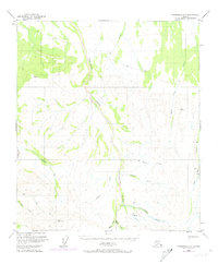
1950 Map of Fairbanks A-3
USGS Topo · Published 1974About this map
Tatlanika Creek dominates this interior Alaskan landscape, which was documented by the Geological Survey during the mid-20th century. The terrain is characterized by a network of drainages such as Saint George Creek and Roosevelt Creek that feed into the larger river systems. Evidence of gold mining activity is visible through several Placer Mines located near the confluence of Moose Creek and Sheep Creek, along with a significant Ditch following the path of Gold King Creek. These features indicate the region's reliance on hydraulic mining and specialized transport, including a Sled Road and a remote Landing Strip. Human presence is sparse, marked only by isolated landmarks like a solitary Cabin and high survey points such as VABM Murphy 4830, reflecting the frontier nature of the Tanana Valley foothills.
Find a feature on this map
21 named features on this map. Tap any name to fly to it.
Don’t see what you’re looking for? This feature index may not catch every label — zoom into the map to look around manually.
Map Details
Editions of this 1950 Fairbanks A-3 Map
4 editions found
Other maps of this area

1949 · Fairbanks B-4
USGS Topo · 1:63,360

1949 · Fairbanks B-3
USGS Topo · 1:63,360

1949 · Fairbanks A-2
USGS Topo · 1:63,360

1950 · Fairbanks
USGS Topo · 1:250,000

1950 · Healy D-4
USGS Topo · 1:63,360

1950 · Fairbanks A-4
USGS Topo · 1:63,360

1950 · Fairbanks A-3
USGS Topo · 1:63,360

1950 · Fairbanks B-2
USGS Topo · 1:63,360

1950 · Healy D-3
USGS Topo · 1:63,360

1951 · Healy
USGS Topo · 1:250,000