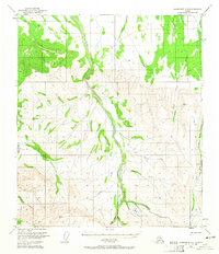
1950 Map of Fairbanks A-3
USGS Topo · Published 1965About this map
Tatlanika Creek dominates this interior Alaska landscape, carving a primary drainage route through the northern foothills. Photogrammetric methods from 1949 reveal a remote region defined by high peaks and narrow stream valleys where industrial mining activity persists in the wilderness. The presence of a Placer Mine and a long Ditch near Grubstake Creek indicates active gold extraction efforts at the middle of the twentieth century. Transport is limited to primitive routes, including a Sled Road in the north and a remote Landing Strip near the creek's lower reaches. High elevation benchmarks like VABM 4830 Murphy and VABM 2879 Gold emphasize the steep verticality of the terrain, while isolated structures like a Cabin near King Creek mark the sparse human presence in this mining district.
Find a feature on this map
22 named features on this map. Tap any name to fly to it.
Don’t see what you’re looking for? This feature index may not catch every label — zoom into the map to look around manually.
Map Details
Editions of this 1950 Fairbanks A-3 Map
4 editions found
Other maps of this area

1949 · Fairbanks B-4
USGS Topo · 1:63,360

1949 · Fairbanks B-3
USGS Topo · 1:63,360

1949 · Fairbanks A-2
USGS Topo · 1:63,360

1950 · Fairbanks
USGS Topo · 1:250,000

1950 · Healy D-4
USGS Topo · 1:63,360

1950 · Fairbanks A-4
USGS Topo · 1:63,360

1950 · Fairbanks A-3
USGS Topo · 1:63,360

1950 · Fairbanks B-2
USGS Topo · 1:63,360

1950 · Healy D-3
USGS Topo · 1:63,360

1951 · Healy
USGS Topo · 1:250,000