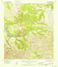
1952 Map of Healy D-4
USGS Topo · Published 1952About this map
Healy and Suntrana serve as the industrial anchors of this interior Alaska landscape, situated at the confluence of the Nenana River and Healy Creek. The map documents a critical period for the regional energy economy, clearly marking the Usibelli Coal Mine and its connectivity to The Alaska Railroad. This rail line tracks the winding course of the Nenana, passing through smaller settlements like Garner and Moody. To the south, the approximate boundary of Mt McKinley National Park is established, marking the edge of the wilderness preserve against the active mining and transit corridor. The terrain is defined by prominent elevations such as Jumbo Dome and Dora Peak, with numerous watercourses like Lignite Creek and Moody Creek carving the valleys. Isolated cabins and a designated Airstrip near Healy reflect the practical infrastructure required for mid-century northern operations.
Find a feature on this map
43 named features on this map. Tap any name to fly to it.
Don’t see what you’re looking for? This feature index may not catch every label — zoom into the map to look around manually.
Map Details
Editions of this 1952 Healy D-4 Map
2 editions found
Other maps of this area

1949 · Healy C-3
USGS Topo · 1:63,360

1950 · Fairbanks
USGS Topo · 1:250,000

1950 · Fairbanks A-5
USGS Topo · 1:63,360

1950 · Healy D-4
USGS Topo · 1:63,360

1950 · Healy C-4
USGS Topo · 1:63,360

1950 · Fairbanks A-4
USGS Topo · 1:63,360

1950 · Fairbanks A-3
USGS Topo · 1:63,360

1950 · Healy D-3
USGS Topo · 1:63,360

1951 · Healy
USGS Topo · 1:250,000

1951 · Fairbanks
USGS Topo · 1:250,000