Old Maps of Lagoon, Alaska for Academic Research
Study the evolution of Lagoon with 5 high-resolution historic maps. Whether you're teaching, researching, or modeling changes in land use, these maps provide essential visual documentation of urban, environmental, and geographic change.
- Analyze long-term change: Track patterns in development, transportation, and natural features.
- Ideal for environmental or urban studies: Support academic projects with primary historical map data.
- Use in the classroom or lab: Educators and researchers rely on these maps to bring historical context to life.
These maps are a powerful tool for teaching, research, and visualizing how Lagoon has changed over the decades.
Lagoon, AK maps
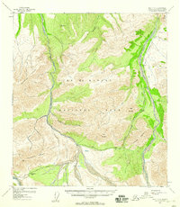
(5)- 1951 Map of Healy
 1951 Healy1951 Print · USGSThe Alaska interior during the early fifties reveals a landscape shaped by the Alaska Railroad and the mining of the Alaska Range. Trace early settlements and infrastructure like Suntrana, the Dunkle Coal Mine, and the McKinley Park Airstrip at the edge of the wilderness.5 unique versions available
 - 1954 Map of Healy C-6, 1958 Print
 1954 Healy C-61958 Print · USGSInterior Alaska during the mid-fifties reveals the early road and trail systems through the wilderness of Mt Mc Kinley National Park. Researchers can trace the original route of the Denali Highway past the Ranger Cabin and Teklanika Campground.6 unique versions available
 - 1956 Map of Healy, 1966 Print
 1956 Healy1966 Print · USGSThe interior of Alaska is shown during a period of industrial and recreational expansion in the mid-fifties. Genealogists and historians can trace the Alaska Railroad corridor through Healy and mining sites like Usibelli Mine.4 unique versions available
 - 2014 Map of Healy C-6 NW, 2014 Print
 2014 Healy C-6 NW2014 Print · USGSCovers Lagoon, including Denali, United States, and other nearby areas
 - 2024 Map of Healy C-6 NW, 2024 Print
 2024 Healy C-6 NW2024 Print · USGSDenali, Alaska is represented here in its modern state as a protected expanse of river valleys and alpine ridges. Researchers can trace the braided East Fork Toklat River and the high peaks of the Wyoming Hills within the Denali Wilderness.
End of results
Showing maps 1-5 of 5
Frequently asked questions
- What are the different types of historical maps available for Lagoon?
- What is the oldest map of Lagoon?
- Where can I purchase historical maps of Lagoon for my home or office?
- Where can I download high-res historical maps of Lagoon?
- Are there historical topographic maps available for Lagoon?
- Is there historical aerial imagery available for Lagoon?
- Where are historical maps of Lagoon sourced from?