Old Maps of Chatanika, Alaska
Explore 10 old maps of Chatanika, spanning from 1945 to today. These high-resolution historic maps reveal how streets, neighborhoods, landmarks, and natural features evolved over time — perfect for genealogy, metal detecting, research, and local history exploration.
What you can do with these maps:
- See how Chatanika changed over time: Compare historical maps to modern-day views to trace roads, homesites, rail lines & more.
- View detailed metadata: Each map includes creators, publishers, year, scale, and archive source.
- Overlay maps with satellite & LiDAR: Visualize the past alongside modern tools to explore terrain & human change.
- Trusted historical sources: Maps sourced from the USGS, Library of Congress, and other archives.
- Access maps your way: View online, download high-res files, or order prints for personal or research use.
Start exploring old maps of Chatanika to uncover forgotten places, hidden landmarks, and the deep history beneath your feet.
Chatanika, AK maps
(10)- 1945 Map of Livengood
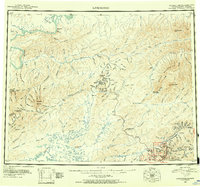 1945 Livengood1945 Print · USGSThe Alaska Interior at the end of World War II reveals a landscape of mining camps and river outposts. Trace the early road network from Chatanika to the gold fields of Livengood, or locate the site of Fort Hamlin.4 unique versions available
 - 1951 Map of Livengood, 1952 Print
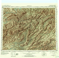 1951 Livengood1952 Print · USGSThe mining corridors of interior Alaska are mapped here during the early fifties, showing the vital links between the Yukon River and the mining camps. Trace early transport routes like the Steese Highway and Sled Roads to find places like Livengood, Chatanika, and Meehan.2 unique versions available
 - 1952 Map of Livengood A-1, 1974 Print
 1952 Livengood A-11974 Print · USGSThe interior of the Fairbanks North Star Borough is captured here during the 1950s gold-mining era. Trace the industrial footprint of Golden City, the Newsboy Mine, and Captain Bluff Camp along the Steese Highway.3 unique versions available
 - 1954 Map of Livengood A-1, 1956 Print
 1954 Livengood A-11956 Print · USGSThe Fairbanks mining district in the mid-fifties is captured here in meticulous detail, showing the industrial evolution of the interior gold fields. Researchers can trace the legacy of early strikes at Cleary Hill Mine and locate the sites of now-vanished settlements like Golden City and Meehan.2 unique versions available
 - 1956 Map of Livengood, 1961 Print
 1956 Livengood1961 Print · USGSInterior Alaska during the mid-fifties reveals a landscape defined by gold mining camps and seasonal trails. You can trace the Railroad Grade and mining sites like Drew Mine or locate historic camps such as Chatanika and Pedro Camp.9 unique versions available
 - 1964 Map of Livengood
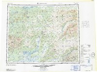 1964 Livengood1964 Print · USGSInterior Alaska during the mid-sixties shows a land shaped by the gold mining industry and new road networks. Researchers can trace the path of the Davidson Ditch and locate historic mining camps such as Pedro Camp, Chatanika, and Golden City.
 - 1992 Map of Livengood A-1 SW
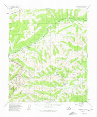
 1992 Livengood A-1 SW1992 Print · USGSAlaska's interior mining district is frozen in time during the early nineties, revealing the deep scars and legacy of the gold rush. Trace the complex web of extraction at the Newsboy Mine and McCarty Mine, or locate the site of the vanished Golden City.
 - 2017 Map of Livengood A-1 SW, 2017 Print
 2017 Livengood A-1 SW2017 Print · USGSCovers Chatanika, including Fairbanks North Star, United States, and other nearby areas
 - 2021 Map of Livengood A-1 SW, 2021 Print
 2021 Livengood A-1 SW2021 Print · USGSCovers Chatanika, including Fairbanks North Star, United States, and other nearby areas
 - 2024 Map of Livengood A-1 SW, 2024 Print
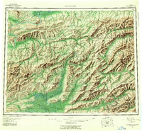
 2024 Livengood A-1 SW2024 Print · USGSThe Fairbanks interior during the early twenty-first century reveals a landscape shaped by mining legacy and highway expansion. Researchers can trace the path of the Chatanika Siphon or locate landmarks like Pedro Dome and the settlement of Chatanika.
End of results
Showing maps 1-10 of 10
Frequently asked questions
- What are the different types of historical maps available for Chatanika?
- What is the oldest map of Chatanika?
- Where can I purchase historical maps of Chatanika for my home or office?
- Where can I download high-res historical maps of Chatanika?
- Are there historical topographic maps available for Chatanika?
- Is there historical aerial imagery available for Chatanika?
- Where are historical maps of Chatanika sourced from?