Old Maps of Lutak, Alaska for Metal Detecting
Plan your next treasure hunt with 5 historic maps of Lutak. Find old homesites, ghost towns, trails, and gathering spots that may be lost to time — perfect for identifying promising metal detecting locations.
- Locate forgotten sites: Uncover places like long-lost settlements, abandoned rail lines, or gathering spots.
- Plan better hunts: Use map overlays combined with LiDAR or satellite views to narrow in on historically rich areas.
- Made for detectorists: Thousands of hobbyists use these maps to discover relics, coins, and hidden history.
Use these historic maps to boost your research and find new opportunities beneath the surface of Lutak.
Lutak, AK maps
(5)- 1952 Map of Skagway, 1953 Print
 1952 Skagway1953 Print · USGSThe northern reaches of the Alaska Panhandle come alive in the early fifties, showing the vital rail and road links to the Yukon. Trace the historic White Pass & Yukon Route or locate remote camps like Pleasant Camp and Klukwan.4 unique versions available
 - 1954 Map of Skagway B-2, 1959 Print
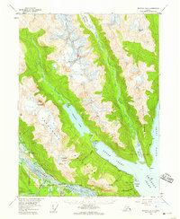 1954 Skagway B-21959 Print · USGSThe Lynn Canal region of Alaska was a landscape of maritime navigation and glacial mountain passes in the mid-fifties. Genealogists and historians can trace the early footprint of the Yindastuki Indian Res and coastal sites like Tanani and Chilkoot.4 unique versions available
 - 1961 Map of Skagway, 1967 Print
 1961 Skagway1967 Print · USGSThe northern reaches of the Panhandle and the rugged border with British Columbia come into focus in the early sixties. Researchers can trace the historic Chilkoot Trail, the White Pass and Yukon Railway, and coastal outposts like Klukwan.4 unique versions available
 - 1991 Map of Skagway B-2 SW
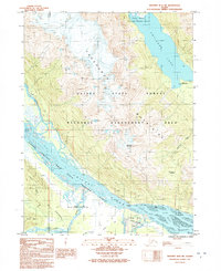 1991 Skagway B-2 SW1991 Print · USGSThis Southeast Alaska territory in the early nineties shows the convergence of the Takshanuuk Mountains and the braided Chilkat River. You can trace the historic Dalton Trail and the bounds of the Alaska Chilkat Bald Eagle Preserve (State).
 - 2017 Map of Skagway B-2 SW, 2017 Print
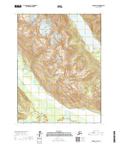 2017 Skagway B-2 SW2017 Print · USGSThe braided waters of the Chilkat valley and the towering Takshanuk range define this corner of Southeast Alaska in the late twenty-teens. Researchers can trace the path of the Haines Highway as it winds past Vanderbilt Point and the shores of Chilkoot Lake.
End of results
Showing maps 1-5 of 5
Frequently asked questions
- What are the different types of historical maps available for Lutak?
- What is the oldest map of Lutak?
- Where can I purchase historical maps of Lutak for my home or office?
- Where can I download high-res historical maps of Lutak?
- Are there historical topographic maps available for Lutak?
- Is there historical aerial imagery available for Lutak?
- Where are historical maps of Lutak sourced from?