1960s Maps of Dobson Landing, Alaska
Explore 2 historic maps of Dobson Landing from the 1960s. These maps offer a rare glimpse into what life looked like during the 1960s — showing old roads, neighborhoods, homes, and landmarks that have changed or disappeared over time.
Whether you're researching your family's past, planning a metal detecting trip, or studying how Dobson Landing's landscape evolved across the 1960s, these high-resolution maps are a powerful tool for exploring the history of this region.
- Focus on a specific era: All maps on this page are from the 1960s, giving you a focused view of this time period.
- See what’s changed: Compare century-old streets, trails, and buildings to today's modern landscape using overlays and satellite layers.
- Research with precision: Use these maps for genealogy, historical research, land use analysis, or educational projects.
- View, download, or print: Maps are fully viewable online in high resolution, and can be downloaded or printed for your own records.
Start exploring Dobson Landing's history through authentic maps from the 1960s. This is your window into the past.
Dobson Landing, AK maps
(2)- 1962 Map of Juneau B-3, 1963 Print
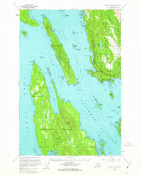 1962 Juneau B-31963 Print · USGSThe Juneau coastline and northern Admiralty Island are captured here in the early sixties, showing the maritime networks of the Inside Passage. Trace coastal history through the Shrine of St Terese, the docks at Dotsons Landing, and the Montana Creek Trail.2 unique versions available
 - 1962 Map of Juneau, 1966 Print
 1962 Juneau1966 Print · USGSSoutheast Alaska in the early sixties showcases a maritime landscape defined by the Tongass National Forest and the peaks of the Coast Mountains. Trace the footprints of coastal industry at Treadwell, Thane, and the regional hub of Juneau.7 unique versions available
End of results
Showing maps 1-2 of 2
Frequently asked questions
- What are the different types of historical maps available for Dobson Landing?
- What is the oldest map of Dobson Landing?
- Where can I purchase historical maps of Dobson Landing for my home or office?
- Where can I download high-res historical maps of Dobson Landing?
- Are there historical topographic maps available for Dobson Landing?
- Is there historical aerial imagery available for Dobson Landing?
- Where are historical maps of Dobson Landing sourced from?