1940s Maps of Fairhaven, Alaska
Explore 2 historic maps of Fairhaven from the 1940s. These maps offer a rare glimpse into what life looked like during the 1940s — showing old roads, neighborhoods, homes, and landmarks that have changed or disappeared over time.
Whether you're researching your family's past, planning a metal detecting trip, or studying how Fairhaven's landscape evolved across the 1940s, these high-resolution maps are a powerful tool for exploring the history of this region.
- Focus on a specific era: All maps on this page are from the 1940s, giving you a focused view of this time period.
- See what’s changed: Compare century-old streets, trails, and buildings to today's modern landscape using overlays and satellite layers.
- Research with precision: Use these maps for genealogy, historical research, land use analysis, or educational projects.
- View, download, or print: Maps are fully viewable online in high resolution, and can be downloaded or printed for your own records.
Start exploring Fairhaven's history through authentic maps from the 1940s. This is your window into the past.
Fairhaven, AK maps
(2)- 1947 Map of Juneau B-3, 1955 Print
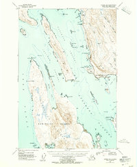 1947 Juneau B-31955 Print · USGSThe coastal waters north of Juneau come alive in the late 1940s, showing a maritime landscape of channels and remote landings. Researchers can trace early infrastructure like the lighthouse at Point Retreat, the small settlement at Dotsons Landing, and the original Glacier Highway route.2 unique versions available
 - 1949 Map of Juneau B-3
 1949 Juneau B-31949 Print · USGSThe Juneau coastline in the late 1940s is shown here as a landscape of maritime channels and early highway development. Researchers can trace historic access points like Dotsons Landing, the St Terese mission, and remote inlets such as Funter Bay.
End of results
Showing maps 1-2 of 2
Frequently asked questions
- What are the different types of historical maps available for Fairhaven?
- What is the oldest map of Fairhaven?
- Where can I purchase historical maps of Fairhaven for my home or office?
- Where can I download high-res historical maps of Fairhaven?
- Are there historical topographic maps available for Fairhaven?
- Is there historical aerial imagery available for Fairhaven?
- Where are historical maps of Fairhaven sourced from?