1950s Maps of Kalifornsky, Alaska
Explore 4 historic maps of Kalifornsky from the 1950s. These maps offer a rare glimpse into what life looked like during the 1950s — showing old roads, neighborhoods, homes, and landmarks that have changed or disappeared over time.
Whether you're researching your family's past, planning a metal detecting trip, or studying how Kalifornsky's landscape evolved across the 1950s, these high-resolution maps are a powerful tool for exploring the history of this region.
- Focus on a specific era: All maps on this page are from the 1950s, giving you a focused view of this time period.
- See what’s changed: Compare century-old streets, trails, and buildings to today's modern landscape using overlays and satellite layers.
- Research with precision: Use these maps for genealogy, historical research, land use analysis, or educational projects.
- View, download, or print: Maps are fully viewable online in high resolution, and can be downloaded or printed for your own records.
Start exploring Kalifornsky's history through authentic maps from the 1950s. This is your window into the past.
Kalifornsky, AK maps
(4)- 1950 Map of Kenai
 1950 Kenai1950 Print · USGSThe Kenai Peninsula and Cook Inlet appear here during a pivotal era of mid-century growth and road construction. Researchers can trace the early layout of Soldotna, locate the Snug Harbor Cannery, and see the footprint of Salamatof.2 unique versions available
 - 1951 Map of Kenai B-4, 1967 Print
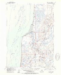
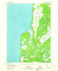 1951 Kenai B-41967 Print · USGSThe Kenai Peninsula coastline at the start of the 1950s shows a landscape of fishing settlements and early industrial expansion. Trace the growth of Kalifonsky and Cohoe, or locate historic Gas Wells and the remote Kasilof Landing Strip.2 unique versions available
 - 1952 Map of Kenai B-4, 1954 Print
 1952 Kenai B-41954 Print · USGSThe Kenai Peninsula coastline near Kasilof was a rugged frontier of fishing and homesteading in the early fifties. Genealogists and local historians can trace early settlements at Cohoe, remote Cabins, and the navigation markers at Hongkong Bend.3 unique versions available
 - 1958 Map of Kenai, 1967 Print
 1958 Kenai1967 Print · USGSThe Kenai Peninsula and Cook Inlet are captured here during a period of mid-century growth and wilderness management. Researchers can trace early settlements and infrastructure like Nikishka No 1, Salamatof, and the Wildwood Military Reservation.6 unique versions available
End of results
Showing maps 1-4 of 4
Top cities near Kalifornsky
Frequently asked questions
- What are the different types of historical maps available for Kalifornsky?
- What is the oldest map of Kalifornsky?
- Where can I purchase historical maps of Kalifornsky for my home or office?
- Where can I download high-res historical maps of Kalifornsky?
- Are there historical topographic maps available for Kalifornsky?
- Is there historical aerial imagery available for Kalifornsky?
- Where are historical maps of Kalifornsky sourced from?