Old Maps of Ninilchik, Alaska
Explore 8 old maps of Ninilchik, spanning from 1944 to today. These high-resolution historic maps reveal how streets, neighborhoods, landmarks, and natural features evolved over time — perfect for genealogy, metal detecting, research, and local history exploration.
What you can do with these maps:
- See how Ninilchik changed over time: Compare historical maps to modern-day views to trace roads, homesites, rail lines & more.
- View detailed metadata: Each map includes creators, publishers, year, scale, and archive source.
- Overlay maps with satellite & LiDAR: Visualize the past alongside modern tools to explore terrain & human change.
- Trusted historical sources: Maps sourced from the USGS, Library of Congress, and other archives.
- Access maps your way: View online, download high-res files, or order prints for personal or research use.
Start exploring old maps of Ninilchik to uncover forgotten places, hidden landmarks, and the deep history beneath your feet.
Ninilchik, AK maps
(8)- 1944 Map of Kenai, 1954 Print
 1944 Kenai1954 Print · USGSThe Kenai Peninsula and Cook Inlet are captured here during a period of postwar growth, just as the regional road system began to expand. Genealogists and historians can trace early settlements and family landmarks such as Salamatoff, Stelters Ranch, and the Snug Harbor Cannery.4 unique versions available
 - 1950 Map of Kenai
 1950 Kenai1950 Print · USGSThe Kenai Peninsula and Cook Inlet appear here during a pivotal era of mid-century growth and road construction. Researchers can trace the early layout of Soldotna, locate the Snug Harbor Cannery, and see the footprint of Salamatof.2 unique versions available
 - 1951 Map of Kenai A-5, 1960 Print
 1951 Kenai A-51960 Print · USGSThe Kenai Peninsula coastline comes into focus in the early fifties as the modern road network begins to take shape. Researchers can trace early family holdings at Jackinsky Ranch or locate aviation history at the Ninilchik Landing Strip and Cape Ninilchik.3 unique versions available
 - 1952 Map of Kenai A-5, 1954 Print
 1952 Kenai A-51954 Print · USGSThe Kenai Peninsula coastline comes into focus in the early fifties, showing the interplay between tidal waters and early Alaskan road networks. Researchers can trace the path of the Sterling Highway past the Jackinsky Ranch and the coastal hub of Ninilchik.2 unique versions available
 - 1958 Map of Kenai, 1967 Print
 1958 Kenai1967 Print · USGSThe Kenai Peninsula and Cook Inlet are captured here during a period of mid-century growth and wilderness management. Researchers can trace early settlements and infrastructure like Nikishka No 1, Salamatof, and the Wildwood Military Reservation.6 unique versions available
 - 1987 Map of Kenai A-5 SE
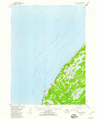
 1987 Kenai A-5 SE1987 Print · USGSThe Kenai Peninsula coastline near Ninilchik comes into focus in the late eighties as a hub of river-mouth settlement and coastal transit. Trace local landmarks like the Cem, the Ninilchik Airport, and the paths of Deep Creek and the Ninilchik River.
 - 2018 Map of Kenai A-5 SE, 2018 Print
 2018 Kenai A-5 SE2018 Print · USGSCovers Ninilchik, including Kenai Peninsula, United States, and other nearby areas
 - 2024 Map of Kenai A-5 SE, 2024 Print
 2024 Kenai A-5 SE2024 Print · USGSThe western Kenai Peninsula comes into focus in this contemporary survey of the Ninilchik coast. Genealogists and historians can trace local family roots at the Transfiguration of Our Lord Russian Orthodox Cem or locate the Ninilchik Airport and Happy Valley.
End of results
Showing maps 1-8 of 8
Frequently asked questions
- What are the different types of historical maps available for Ninilchik?
- What is the oldest map of Ninilchik?
- Where can I purchase historical maps of Ninilchik for my home or office?
- Where can I download high-res historical maps of Ninilchik?
- Are there historical topographic maps available for Ninilchik?
- Is there historical aerial imagery available for Ninilchik?
- Where are historical maps of Ninilchik sourced from?